

2026 spring bear hunting forecast
Take a look at what hunters can expect in 2026 for their specific hunt areas, details provided by wildlife biologists throughout the state.
Statewide prospects
Bear emergence is closely tied to green up, when forbs and grasses start to emerge. These are important food sources for bears as they emerge from their dens.
The timing of green up, and bear emergence, will vary in parts of the state depending on winter snowpack and spring conditions. Due to mild winter conditions to date, snowpack is minimal, resulting in increased accessibility and earlier spring conditions but of course check local conditions for your unit before heading out to hunt or scout. Please keep vehicles off wet and muddy roads to avoid damaging roads and fish and wildlife habitat.
Hunters often use the spring hunting season as an opportunity to scout new hunting areas for next fall's deer and elk seasons, turkey hunt or collect shed antlers. Remember it's legal to take naturally shed antlers, but not skulls with antlers attached. More information on shed hunting.
2025 black bear harvest statistics
In 2025 hunters checked-in 1,937 black bears in Oregon – 831 during the spring season and 1106 in the fall. The links below break down these harvest numbers by WMUs.
Tips to be a better bear hunter
An avid bear hunter and ODFW wildlife biologist, offers his tips for being a better bear hunter:
- Wait for bear emergence and green up conditions during season.
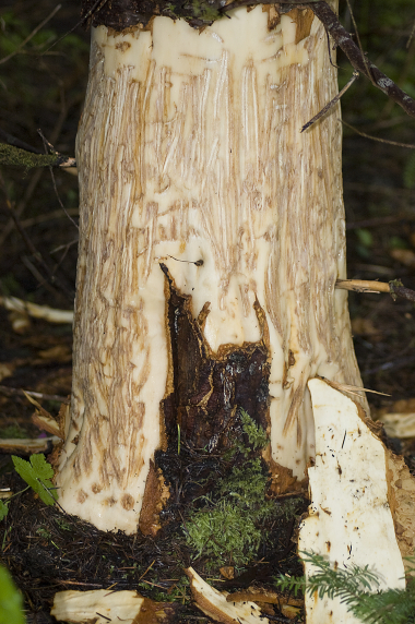
- Look for tracks and signs of activity.
- Save the midday hours for lunching and napping.
- Start your season with some early or pre-season scouting.
- Start walking later in the season.
- Consider calf and fawn distress calls.
- Avoid detection. Stay downwind.
- Remember it's illegal to harvest cubs and sows with cubs – emphasize ethical shot.
- Take special care field dressing, guidelines available inside Big Game regulations.
- Check in your harvested bear after the hunt.
Regulation requirements
Check-in your bear
Successful bear hunters must check-in their bear's skull at an ODFW office within 10 days of the harvest so biologists can collect a tooth and other biological information.
Please call your local ODFW office in advance to make sure a field biologist is available and make an appointment. When you arrive, please make sure the bear's skull is unfrozen.
Here's more information you'll need to check your bear in.
Report your hunt
All hunters who purchase a 2026 spring bear tag are required to report their hunt results online or at a license agent no later than Jan. 31, 2027. Reporting is required even for those who did not hunt or were unsuccessful. ODFW uses this information to determine harvest, effort in specific areas and set future hunting regulations. Learn how to report
Northwest Area
Northwest/Willamette Area -- Hunt 710A: Units 10, 11, 12, 14, 15, 16, and 19
Saddle Mtn–Scappoose--Current data shows that bears are distributed throughout the Saddle Mtn Unit, with higher densities in the western half of the unit. There are very few bears harvested in the Scappoose unit. To find bears, hunters need to concentrate their efforts early in the season near food sources like skunk cabbage (typically found along riparian zones and wet bottomlands) and grass patches on south and southwest facing slopes. Given the mild winter conditions this year, expect bears to be mobile early in the season.
Following a few sunny days, clear-cuts or open areas adjacent to drainages can also provide spot-and-stalk opportunities for foraging or traveling bears. As Spring brings in warm sunny days, snow free areas where green-up is proceeding more rapidly can be very productive as hungry bears may utilize these areas during much of the day. As in most years, general bear activity should improve as weather patterns move away from freezing snaps and become more stable.
Wilson-Trask--Black bear density in the Wilson and Trask WMU's tend to be greater in the Western half of the Units. Early season bears may only be active on warm days and will likely concentrate on the few foods available in early spring; including grass, skunk cabbage and down wood that holds termites and carpenter ants. This year's mild winter should make for a productive Spring hunt. Keep in mind that late freezing weather and snow could set back Spring green up, especially at higher elevations.
Willamette--Few bears are harvested in this unit since the valley is too heavily 'people' populated, limited numbers can be found on private property or on the outskirts of adjoining units with higher elevations and heavier wooded areas.
Santiam-McKenzie--Bear densities remain stable in the north and central Cascades. Fire closures in many areas have been lifted, but some road closures remain from recent winter storms. Hunters will need to check with Mt. Hood and Willamette National Forests for the most up-to-date road closure information. Some of the areas previously closed due to fires could be good areas to target for bear hunting, especially if the fire severity was low to moderate.
Fall and winter conditions were mild in 2025 and 2026, respectively. Consequently, early March 2026 conditions exhibit favorable green up conditions for spring bear hunts. Some bears have been reported moving at the end of February, which is unusual and is typically delayed until early April. Hunters should expect earlier bear activity than previous years unless April weather conditions are colder and wetter than normal. Bear activity increases during the third week of April in normal years and may also occur at higher elevations earlier in the season than typical years.
The snowpack in the Willamette Basin is currently well below average (~32% as of late February), so hunters may have easier access than normal navigating through the forest. The NRCS/USDA Oregon Snow Survey is a great resource for information on snowpack. Hunters should check road conditions and access before heading out, especially early in the season. Many low- and mid-elevations currently have very minimal snow, providing good accessibility across the hunt area. In areas that have snow, look for warm weather stretches to open up new habitat as the season progresses. While many roads may be free of snow, mud will continue to be challenging through the spring. Please be aware of road conditions and avoid driving on soft or muddy roads.
Given the mild winter conditions this year, expect bears to be mobile early in the season. If you want to get out early, start along riparian corridors at lower elevations and focus on south and southwest facing slopes. The key to early success is to target days with some sun and mild weather. As green up starts to occur bears can be found feeding in clear cuts and grassy meadows, providing more spot-and-stalk opportunities. Obviously, finding freshly torn up stumps and scat is a great indication of bear activity in the area. Bears will often feed in the same area for multiple days at a time, so these areas are good spots to target. As in most years, general bear activity should improve as weather patterns move away from freezing snaps and become more stable.
Locations: See the Oregon Hunting Access Map. The boundary for this hunt changed recently to include all the McKenzie and Santiam units. However, many private timber companies still do not allow access. Make sure you check on access before you go hunting.
Hunters can find good concentrations of bears in the Salmon-Huckleberry Wilderness Area. The Forest Service has been doing meadow restoration projects that, once free of snow, often have good grass growth the bears will key-in on. Hunters can find these areas on Google Earth. Other areas to look include the Santiam State Forest, up the Breitenbush drainage, and in some of the "checkerboard" properties owned by USFS and private timber companies. In the McKenzie, hunting is best late in the season in some of the old, brushy clear-cuts in the North Fork of the Middle Fork Willamette River and South Fork McKenzie drainages.
Alsea-Stott Mtn -- 717A & 717T
The Alsea and Stott Mountain units have experienced a relatively mild winter with short periods of snow in higher elevations. Most snow will be melted by April 1 with new vegetation sprouting throughout spring. Black bears tend to target this new growth as their primary spring food source. Focus efforts where vegetation growth occurs first; riparian areas, south facing slopes, meadows, decommissioned grassy roads. From there it is beneficial to follow the green up as it moves up in elevation. Black bears normally won't leave a food source so stick to an area that has fresh bear sign and food. Be patient and watch for signs of cubs before attempting to take a bear.
The Mid-Coast Travel Management Area is still open. A map and additional information of the TMA can be found here.
Southwest Area
Hunt 722A: Units 20, 21, 22, 23, 24, 25, 26, 27, 28, 29 and 30 *Lands within one mile of the Rogue River between Grave and Lobster creeks are closed to bear hunting.
Bear numbers in the southwest are high and likely increasing. However, the bear population density is highest closer to the coast in the Coast Range. Bear numbers are also very high in the Southern Cascades and Siskiyou mountains, including the Applegate, Rogue, and Evans Creek WMUs.
Black bear hunting this spring should be good right from the start of the season. We have had a relatively mild winter and our snowpack in the high elevation is low so the grass green up bears rely on this time of year should start beginning of April.
The Coast Range may see downed trees from winter storms will likely be an issue for hunters. Hunters should be prepared to deal with downed trees or have a backup plan for hunting locations in the event they can't get to their preferred hunting areas.
Typically, May is the better month to hunt as bears will be moving around more prior to the June rut, and vegetation growth accelerates with warmer temperatures. Also, by May most roads have been cleared of downed trees.
Boars tend to emerge from their dens earlier than sows and cubs. Remember it's illegal to harvest a sow with cubs. In general, it's good to start the season by glassing open hillsides during sunny mornings and evenings. Bears will most likely be out at this time feeding on grasses and anything else that can fill their bellies.
Hunters are encouraged to keep checking the website for updates as the hunting season approaches and throughout the duration of the season. In general, lower elevations tend to green up first so hunters should focus their efforts there during the early part of the season, and then move up in elevation as the snow melts. Early in the season, focus on bear foraging evidence and tracks. After a couple weeks, bear digestive tracts will become more active and scat will serve as another indicator of bear activity.
Increased bear activity will most likely occur on decommissioned untraveled skid roads with high grass production. When bears are active, they will be looking to feed in these grassy openings or similar meadow-type ranges. Coastal wetlands, mid-elevation meadows, mountain prairies and riparian areas are other good places to look for bears. Hunters with access to private timberlands will find bears in clear-cuts, either feeding on green grass or tearing apart stumps looking for insects. Focus on south-facing hillsides in the early mornings and evenings, typically bears will be more active during these times.
Please be mindful of road access conditions. Even this winter's mild snowfall has the potential to create impassable snowdrifts, especially on north-facing slopes. Hunters may want to drive roads they intend to hunt ahead of time to make sure that the roads are passable.
Columbia Area
White River-Hood River--Hunt 741A: Units 41 & 42
Snowpack on and around Mt. Hood has been lower than normal (as of February), following the trend seen around the west this year. With a lack of snow, road access to higher elevations and roads on ridges will likely be more accessible than in past years. The most common way of scouting is glassing clear cuts using maintained logging roads to move around. We have had reports and personal sightings of unusually high bear activity throughout the winter. With the extremely mild-winter and higher bear activity, hunters will not have to wait to see larger bear movement. Once the season is open, hunters will have good opportunity to hunt unrestricted in a majority of the units.
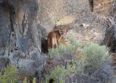
Hunters can deploy several tactics to be successful, including still hunting in timber or glassing clear cuts, both good areas for calling and spotting. Calling also increases your likelihood of coming across a mountain lion, so have a valid cougar tag on hand (mountain lion/cougar tags can be purchased at any time each year, but a valid tag is needed before harvest for a legal take).
South Central Area
Hunt 731A: Units 31, 32, 33, 74, 75, 76 and 77
Snowpack is currently well below average (around 35% normal) due to the La Nina weather patterns this winter. Most lowlands and mid-elevations are snow-free providing plenty of accessibility across the hunt area. In areas that have snow, look for warm weather stretches to open up new habitat as the season progresses for fresh green up which is attractive to spring bears. While many roads may be free of snow, mud will continue to be challenging as the higher elevation snow melts. Please be cognizant of road conditions and avoid driving on soft or muddy roads.
Bear populations continue to increase throughout the hunt area but remain lower than other portions of the state. Historically the highest bear densities are in the Cascade Mountains with lower densities in the drier, ponderosa pine forest portions further east in the hunt area. However, over the past several years there have been population increases in the Silver Lake, Warner, and Interstate WMU's as well as increased hunter success in these units.
Bear activity will increase as the season progresses, as the temperatures warm and more food becomes available. This increase in activity will result in more bears moving around and increasing the odds of hunters encountering a bear. Often, the afternoon/evening can be the optimal time of the day.
Locations: As mentioned above, the highest density bear populations occur in the Cascades, in this case, the Keno and western Sprague units. Hunting access can be limited, even in the southern portions of the Keno Unit. Many native surface two-track roads and trails will be too muddy to be driven without causing damage to the road. Access should improve by later in the season. Please respect areas where private property is available for hunters and avoid driving on soft or muddy roads.
Yamsey Mountain and Winter Rim areas of the Silver Lake Unit are also places to begin looking as those areas can hold good numbers of bears. The Gearhart Mountain area in the Interstate Unit is another place to begin. Much of this hunt area has burned over the last five years, so focusing on the fringes of the burns can yield success. The fringes can provide cover in the unburnt portions, and fresh feed in the burned portions of the units. Other places to look include south-facing slopes which will often become snow-free and green up with fresh forage faster than other areas.
The Keno Unit can provide good bear hunting opportunities in the Green Diamond Resource Area Access and Habitat lands. Please drive on rocked roads to avoid damage to the road system.
S. Blue Mtns
Hunt 746A: Units 37, 38, 45, 46, 47, 48, 50, 51, 65, 66, and 72
We are seeing exceptionally low snowpack in the South Blues this year. Access should be fairly easy at low to medium elevations, and high elevation areas will likely be accessible earlier than normal. Hunters should keep an eye on snow conditions as the season approaches and plan to target emergent food sources on exposed south slopes and meadows that will melt off sooner. In the South Blues, bear populations are concentrated in wetter high elevation areas and occur at lower densities in more arid locations.
Hunters can try a variety of tactics including still hunting lower elevation meadows and riparian areas early season and transition to spot and stalk as larger open mountain faces become snow free later in the season. Calling may also be effective, be sure to have a cougar tag as well, as they frequently come into calls.
Snow within the hunt area is currently at 24% of the median. With little snow accumulation this winter, access to higher elevations will be available to hunters targeting spring bear in the area. Green up is already occurring throughout the district and mild conditions could have bears emerging from dens earlier this year. Typically bears begin emerging early March and become fully active around the first or second week of April.
In 2025 combined Bear harvest for this hunt was 21 bears, with the highest harvest rates occurring in Murderer's Creek (5 bears) and Beulah (4 bears) WMU's. Typically, Grant County has a higher density of bears and looking north from the south end of county line is a good starting place to look for bears. Various methods can be used to target bears. Look for small meadows with dense cover surrounding them, or openings adjacent to riparian areas and use a predator call such as fawn or elk calf in distress. Many hunters find high elevation areas where they can use high powered spotting scopes and binoculars to find bears feeding in spring green up. However, bears also target prey animals, so finding where the prey base is at can benefit a hunter also.
For more information on where to look for your spring bear call your local ODFW District Office to speak with a wildlife biologist.
Northeast Area
Starkey-Ukiah--Hunts 752A: Units 49 and 52
Snowpack in NE Oregon is substantially lower than normal, much like most of the Western U.S. We are potentially expecting some heavy mountain snow, but even with that, our snowpack will likely be much lower than in years past. Access should be fairly easy in all lower elevations, with the higher elevations being accessible much earlier in the season. Hunters in the Mt. Emily unit should be pleased this year with how accessible that unit could be, compared to years past when driving on the Summit Road is not possible until mid-May.
Bears come out of their state of torpor in late winter/early spring. Early season they tend to be lower in elevation and in somewhat timbered areas where there is lush green grass first. Tactics are a little different this time of year, because setting up to glass big open south facing slopes can be unproductive until there is abundant forage such as balsamroot and wild onions starting to emerge. Hunters should focus their efforts on the lower elevation bands where glassing opportunities may not be as good until there is widespread green up. Bears can pop into view very quickly and a shot can present itself quickly, and if you are not ready to shoot you may lose your chance. Once the temperatures have warmed up a bit in the late spring season, grasses and forbs are all growing on big open south facing slopes, hunters should set up where they have a good vantage point to glass over a lot of country. This time of year bears will be cruising around eating on these open slopes and being in a position to see a lot of country is your best bet to glass them up. Other techniques that can work better this time of year include calling with fawn/calf distress calls as they are getting close to hitting the ground.
Mt Emily-Walla Walla--754A & 754T - Units 54 and 55
Like the rest of the state, Umatilla Co. has experienced below average snow accumulation this winter. Spring bear season in the Mt. Emily and Walla Walla units are heavily influenced by snow levels which often limit access at mid to high elevations areas until late in the season. This year hunters will likely be able to access these higher elevation areas earlier in the season.
Bears typically move up slope following the spring green-up as the snow line recedes. Timbered slopes with small openings that support lush green grass and sedge growth will attract bears. They will also be found on open slopes foraging on wild onions and sedges, especially if we have a wet spring. Hot days will often keep bears out of sight during mid-day so focus on early morning or late afternoons to glass for bears.
Manulife properties will be open to the hunting public throughout the 2026 spring bear season but will require a permit for entry beginning June 1, 2026. Hunters can call the Pendleton ODFW office (541) 276-2344 to obtain information on road closures and current snow conditions.
Wallowa District--Hunt Units 756, 756T, 757A, 757T, 759, 760A & 760T
The district experienced low snowfall in the mid to upper elevations; hunters should expect access to be limited in these areas early in the season. Additionally, the district experienced a heavy windstorm that resulted in numerous trees down across the landscape. Please check with the Wallowa Whitman National Forest, Wallowa Mountains Office at (541) 426-5546 or the Umatilla National Forest Office at (541) 278-3716 for updates on forest road conditions.
Access to lower elevation areas should be relatively easy if the weather conditions hold and there is no late season snow. In the early season, bears can often be found in the canyon areas. Glass south-facing slopes at low and mid-elevations, focusing on areas with signs of early green up.
Locations: See the Oregon Hunting Access Map. Also, be mindful of public land access and consult travel management area maps where applicable. The Noregaard, Whiskey Creek and Shamrock travel management areas in the Sled Springs Unit, Grouse Lick in the Imnaha Unit, and Chesnimnus travel management areas will be in effect through May 31. There is no public access from the Imnaha Highway at Big Sheep Creek, Bear Gulch, and Devil's Gulch in the Imnaha nor access from the west into Lightning Creek and Horse Creek in Snake River.
Manulife properties will require a permit for entry beginning June 1, 2026.
Pine Cr-Keating-Catherine Cr--Hunt 762A: Units 53, 62 and 63
The district experienced moderate snowfall in the mid to upper elevations. Hunters should expect access to be limited early in the season with access to high elevations by mid-season. Access to lower elevation areas should be better this year than normal if the weather conditions hold and there are no late season snows. Look for bears in areas of early green-up. Usually south-facing slopes are the first to become snow-free and can be good places to glass for bears.
Higher elevations near Pine Creek and McGraw Overlook will have snow early in the season but should become accessible by mid-season. For up-to-date road conditions please contact the Wallowa Whitman National Forest, Baker Ranger District at (541) 523-6391. In the Keating Unit, hunters will find better access in some of the mid to low portions of the national forest.
The Catherine Creek Unit will produce good bear numbers this year. Much of the unit's lower elevations are on privately-owned land. The higher elevations of the Catherine Creek Unit are mostly within the Wallowa-Whitman National Forest and contain excellent bear habitat. Snow may limit access to the highest elevations in April but should open up by mid-season. Walking in on roads that are inaccessible by vehicle can be a productive way to find early season bears.
Locations: See the Oregon Hunting Access Map. The Little Catherine Creek Travel Management area just east of Union provides walk-in access to Hancock Forest Management lands; maps are available at entrance points or at ODFW's La Grande Office.
Lookout Mt. Unit--Hunt 764
Moderate snow in high elevations will limit access in the early season. Try south-facing slopes near the timberline above Brownlee Reservoir. Private lands limit access; make sure you obtain landowner permission before hunting private land.
Locations: See the Oregon Hunting Access Map.

Find the latest Recreation Report
Current conditions and opportunities to fish, hunt and view wildlife. Updated weekly by fish and wildlife biologists throughout the state.