

Where crab and clam in the Siuslaw River
The Siuslaw River runs past the city of Florence and then flows for 4 miles before reaching the Pacific ocean. Areas west of the 101 bridge feature excellent seasonal crabbing and even some good diving.
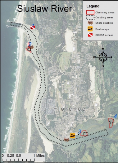
Areas
North Jetty fish ladder access point
An old fish ladder off of N. Jetty Road in Harbor Vista Park provides good SCUBA access, locally known as "the crab hole" (access point #1).
South Jetty docks and flat (SJ)
Purple varnish clams are found on flats on either side of the crab dock (access point #2). Dock crabbing valuable seasonally.
Florence docks (FD)

Softshell clams are found on the flats adjacent to the docks (access point #3).
North Fork flat (NF)
This area is easily accessed on the east end where Highway 126 crosses the north fork of the Siuslaw River (access point #4). There are gravel pullouts on either end of the bridge; be cautious of traffic. This area is very productive for softshell clams; a shovel or clam gun is most effective.
Boat launches
Port of Siuslaw
South end of Harbor Street, just south of 1st Street (fee applies).
Information provided is a result of ODFW creel and population surveys, spot checks, and input from local residents. The purpose of this map is to provide the user with information and locations of recreational shellfish areas where the most likelihood of success may be found by species. Clam species identified within a particular area represent the most abundant found; other species may be present or may exist in areas not identified on the map. This is to be used as a reference as sandbars, clam beds, and species composition can shift over time. Always use caution when boating/crabbing in the lower bay as swift currents during tidal exchanges can occur, and result in loss of gear or cause boat to be pulled out to sea if mechanical problems arise. Developed 2014.
Header photo by Bonnie, Flickr

Check out the current Recreation Report
Current conditions and opportunities to crab and clam. Updated weekly by shellfish biologists.