

Where to crab & clam in Coos Bay
Coos Bay is Oregon’s largest bay. The lower bay (areas from the ocean entrance to the airport) is “marine dominated”, meaning there is little freshwater influence, and offers some of Oregon’s most productive shellfishing opportunities.
General crab and clam map
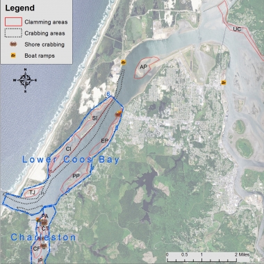
Areas
Lower Coos Bay
Includes areas of the North Spit on the west side of the bay and easily accessible areas along Cape Arago Highway.
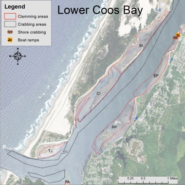
Printable map
North Spit
The western side of lower Coos Bay features very popular boat crabbing and gaper and butter clam digging. Access is difficult (4x4 road or boat only). The paved road ends at the former aquaculture facility (access point #6); gaper and butter clams are found densely throughout. Other species of bay clams are harvested less often, but can be found.
Strawberry Island (SI)
This is the only vegetated island in lower Coos Bay. Gaper and butter clams are easily dug along the muddy shoreline and large butter clams can be dug in the gravely beds around the island.
Clam Island (CI)
This “island” emerges at a +2 or lower tide and is only accessed by boat. Aptly named, “Hungryman's Cove” is a small channel that separates the shoreline from the island and a good place to crab on a windy day.
The island features the highest densities of gaper and butter clams in Coos Bay. Cockle and native littleneck clams are also found here. Shoreline flats boast excellent gaper and butter clamming.
Training Jetty (TJ)
This tideflat, contained between the shoreline and the “training jetty”, is known to have large gaper clams often deep due to shifting sands.
Along Cape Arago Highway
Clamming along Cape Arago Highway is excellent and easily accessible from multiple points. Gaper and butter clams are popular to dig throughout these extensive flats.
Pigeon Point (PP)
This expansive clam bed is productive and easily accessed. A good clamming area for butter and gaper clams is adjacent to the county easement area opposite of Grinnel Rd. (access point #4).
Further down the bay, the Fossil Point area (parking area at Beacon Ln., access point #3) has good beds of large butter and gaper clams, however digging can be a little more difficult as the substrates include shell and cobble.
Empire (EP)
The tideflats adjoining Empire are good for gaper and butter clamming. Parking and access is at a city parking area opposite of Fulton Ave. (access point #5).
Sediments are soft and easy to dig in, however holes dug for gapers may cave in easily. Choose to go during low tides.
Charleston area
Clamming in Charleston is excellent throughout and access is easy. Shore crabbing is accessible from a number of docks.
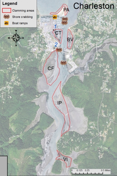
Printable map
Charleston shore crabbing:
Dock crabbing is available throughout the commercial docks in Charleston. Additionally, the Charleston Visitor Center and the T-docks south of the bridge provide excellent dock crabbing.
Point Adams (PA)
Large cockles can be raked along the sandy beach at Point Adams. Gapers occasionally recruit to the beach southwest of the point. Access is at the end of Boat Basin Rd.
Charleston Triangle (CT)
Gapers and butters are abundant here. This area is easily accessed from parking areas south of the docks (access point #1).
Charleston Flat (CF)
Gapers and butters can be dug throughout the areas south of the South Slough Bridge. Cockles can be raked toward the south end of this area. Access is at the Charleston Visitor Center (access point #2)
Barview (BV)
Butter clams throughout in good numbers. Gapers and native littlenecks are also found.
Indian Point (IP)
Boat access only. Cockle, gaper and butter clams can be found throughout.
Valino Island (VI)
Boat access only. Cockle, gaper and butter clams can be found throughout.
Other areas:
Upper Coos Bay (UC)
The areas “up bay” of the railroad bridge are soft and muddy. Softshell clams can be found throughout, finding firm walking substrate is the challenge. Areas around Trans Pacific Ln. and North Slough are occasionally used.
Airport (AP)
Extensive clam beds, west of the runway are rarely accessed, but very productive. Gapers and cockles are found. Boat access only.
Detailed clamming maps
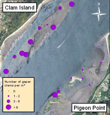
The ODFW SEACOR project
The ODFW SEACOR project conducts bay clam population and habitat studies in the bays along the coast of Oregon. A primary focus is to document the abundance and preferred habitat of several popular bay clam species. These include butter clams, cockle clams, gaper clams, and native littleneck clams.
SEACOR is funded by recreational shellfish license fees, meaning that clammers and crabbers are directly contributing to research on the resources they enjoy.
To learn more about SEACOR, and find additional detailed clamming maps for Tillamook, Netarts, Siletz, Yaquina, Alsea, and Coos bays, visit the SEACOR web page.
Boat launches
Boat launches in Coos Bay can be found at the following locations:
Charleston Boat Ramp
Within the Charleston Marina complex (fee applies)
Empire Boat Ramp
Located at the end of Michigan Ave off Cape Arago Hwy (free)
BLM Boat Ramp
Located on North Spit, but not always open due to sedimentation (free)
California St. Boat Ramp
Located along Hwy 101, in North Bend (free)
Information provided is a result of ODFW creel and population surveys, spot checks, and input from local residents. The purpose of this map is to provide the user with information and locations of recreational shellfish areas where the most likelihood of success may be found by species. Clam species identified within a particular area represent the most abundant found; other species may be present or may exist in areas not identified on the map. This is to be used as a reference as sandbars, clam beds, and species composition can shift over time. Always use caution when boating/crabbing in the lower bay as swift currents during tidal exchanges can occur, and result in loss of gear or cause boat to be pulled out to sea if mechanical problems arise. Developed 2014.
Header photo by Kathy Munsel

Find a Rec Report
Current conditions and opportunities to fish, hunt and see wildlife. Updated weekly by fish and wildlife biologists throughout the state.