

Where to crab & clam in Nehalem Bay
Nehalem Bay offers both beach and boat access to softshell and purple varnish clam beds.
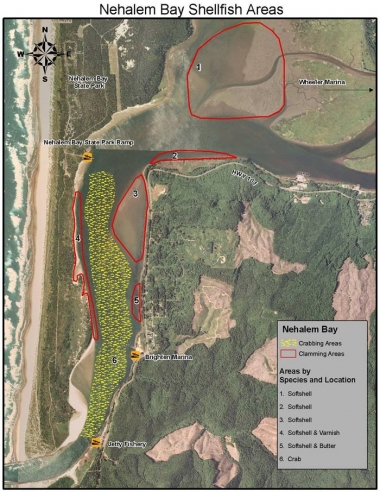
Areas
Area 1
Requires a boat for access. This area is a large mud flat containing mostly softshell clams and walking can be difficult. A shovel or clam gun would be best to use in this area.
Area 2
Requires a boat for access. As with Area 1, this area contains softshell clams, and walking can be difficult. A shovel or clam gun would be best to use in this area.
Area 3
Again as with Areas 1 and 2, you will find softshell clams however the sand is a little firmer and walking isn’t as difficult. A shovel or clam gun would be best to use in this area.
Area 4
Can be reached by either boat or bank/walk-in. Bank/walk-in access is obtained from Nehalem Bay State Park boat ramp area and by walking south. A mix of softshell and purple varnish clams can be found in this area. Here, a shovel or clam gun would be best.
Area 5
Will require a boat for access. This area has a mixture of sand and gravel. Here a shovel or garden fork (heavy tined) would work best for digging. Although softshell clams primarily dominate this area, a few butter clams can also be found.
Area 6
Will require a boat for crabbing. Pots may be set anywhere within this area, using caution to avoid direct placement in navigation channels.
Boat launches
Boat launches in Nehalem Bay can be found at the following locations:
County Boat Ramp
Approximately 1 mile north of Wheeler & 1 mile south of Nehalem. Off Hwy 101 at mile post 46, turn west on Tideland Rd. (not shown on map).
Wheeler Marina
Turn west at city center in Wheeler, next to train depot (not shown on map).
Nehalem Bay State Park boat ramp
1 mile north of Nehalem off Hwy 101, take Necarney Rd to state park and follow signs to boat ramp.
Brighton Marina
Approximately 3 miles south of Wheeler off Hwy 101, near mile post 47.
Jetty fishery
Approximately 3.7 miles south of Wheeler off Hwy 101, near mile post 47.
Information provided is a result of past ODFW surveys, recent spot checks, and input from local residents. The purpose of this map is to provide the user with information and locations of recreational shellfish areas where the most likelihood of success may be found by species. Clam species identified within a particular area represent the most abundant found; other species may be present or may exist in areas not identified on the map. This is to be used as a reference as sandbars, clam beds, and species composition can shift over time. Always use caution when boating/crabbing in the lower bay as swift currents during tidal exchanges can occur, and result in loss of gear or cause boat to be pulled out to sea if mechanical problems arise.
Header image by Dan Germoose, Flickr

Check out the current Recreation Report
Current conditions and opportunities to crab and clam. Updated weekly by shellfish biologists.