Where to crab & clam in Yaquina Bay
Lower Yaquina Bay is “marine dominated”, meaning there is little freshwater influence, and offers many shellfishing oppurtunities.

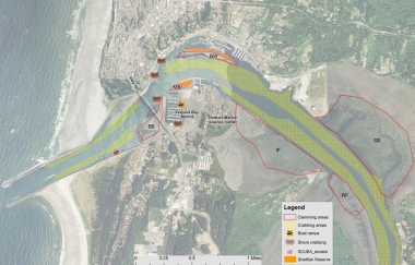
General crab and clam map
Yaquina Bay Shellfish Areas Map
Clamming Areas
Bridge Bed (BB)
One of the most popular clam beds in Yaquina Bay, the Bridge Bed hosts a very healthy population of gaper clams. This clam bed should only be visited at really low tides (less than -1.0) to access the best gaper clam beds. Clammer also can find cockles here, which can be raked on the sandier areas under the bridge.
Marina Bed (MB)
This clam bed contains gaper clams and butter clams. The eastern portion of this bed is off-limits as it is part of an eelgrass mitigation project. See the kiosk near the bathroom for more information.
Breakwater (BW)
This island is only accessible by boat. The north side of the breakwater island is the Yaquina Bay Shellfish Preserve and is off-limits for clamming. The south side is open for clamming and contains very productive gaper and butter clam beds.
Idaho Flat (IF)
This tideflat is accessed by the trailhead at the east end of the Hatfield Marine Science Center Visitor Center parking lot. Clammers have the most luck finding gaper clams by looking near the smaller channel that crosses the middle of Idaho Flat. Clammers also can find good numbers of cockles here but they tend to be smaller than in other areas.
Racoon Flat (RF)
Infrequently visited, this flat can be accessed by boat and has gaper clams.
Sallys Bend (SB)
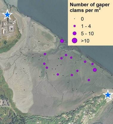
The two access points for the Sally’s Bend tideflat are the gas plant on the west side and Coquille Point to the east. This tideflat is very muddy so be prepared to get dirty. Those who do venture into Sally’s Bend typically find cockles and occasionally littlenecks and gaper clams.
Crabbing areas
Bayfront shore crabbing
Crabbing can be done along Newport’s Bayfront at the Bay St. Pier and the Abbey St. Pier. Dungeness and red rock crabs can be caught here.
Public pier crabbing
The popular pier located near the Rogue Brewery can be productive for Dungeness crab in the summer and fall months. At other times of the year, red rock crab can be caught. Crabbers seem to have the best luck towards the end of the pier.
Boat crabbing
Crabbers with boats set gear throughout Yaquina Bay, avoiding placing gear in the main navigation channel. Crabbing near the north jetty can be productive on an incoming tide, but the waters can be rough for really small boats when the summer wind picks up. Most of the crabbing in Yaquina Bay occurs upriver near the gas plant, on either side of the main navigation channel.
SCUBA ACCESS
The south jetty features a number of sand entrainment structures, often referred to as "the fingers." They make nice shore or boat dives but should only be attempted at slack water.
Detailed clamming maps
The ODFW SEACOR project
The ODFW SEACOR project conducts bay clam population and habitat studies in the bays along the coast of Oregon. A primary focus is to document the abundance and preferred habitat of several popular bay clam species. These include butter clams, cockle clams, gaper clams, and native littleneck clams.
SEACOR is funded by recreational shellfish license fees, meaning that clammers and crabbers are directly contributing to research on the resources they enjoy.
To learn more about SEACOR, and find additional detailed clamming maps for Tillamook, Netarts, Siletz, Yaquina, Alsea, and Coos bays, visit the SEACOR web page.
Boat launches
South Beach Marina
The main boat launch for crabbers and clammers in Yaquina Bay. Small aluminum boats can be rented from the South Beach Marina and the Embarcadero.
Sawyer’s Landing
A boat lift and moorage.
Information provided is a result of ODFW creel and population surveys, spot checks, and input from local residents. The purpose of this map is to provide the user with information and locations of recreational shellfish areas where the most likelihood of success may be found by species. Clam species identified within a particular area represent the most abundant found; other species may be present or may exist in areas not identified on the map. This is to be used as a reference as sandbars, clam beds, and species composition can shift over time. Always use caution when boating/crabbing in the lower bay as swift currents during tidal exchanges can occur, and result in loss of gear or cause boat to be pulled out to sea if mechanical problems arise. Developed 2015.


