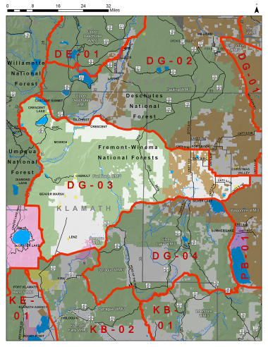
Boundary description
71% public land. Beginning at Silver Lake; west on State Hwy 31 to Bear Flat Rd; west on Bear Flat Rd (named Silver Lk Rd in Klamath Co) to US Hwy 97; west on West Boundary Rd one mile to Sand Cr; southwest on Sand Cr to Crater Lk NP boundary; north and west on Crater Lk NP boundary to Pacific Crest Trail; north on Pacific Crest Trail to State Hwy 58; southeast on State Hwy 58 to Crescent Cutoff Rd (Klamath Co Rd 61); east on Crescent Cutoff Rd (Klamath Co Rd 61) to Crescent; north on US Hwy 97 to NF 9775 at MP 183; north and then east on NF 9775 to NF 2516; north on NF 2516 to State Hwy 31; southeast on State Hwy 31 to Fort Rock Rd (Lake Co Rd 5-10); 22 miles east and south on Fort Rock Rd (Lake Co Rd 5-10) to Christmas Valley Hwy (Lake Co Rd 5-14); east on Christmas Valley Hwy (Lake Co Rd 5-14) to Old Lk Rd (Lake Co Rd 5-14F); southwest on Old Lk Rd (Lake Co Rd 5-14F) to State Hwy 31; west on State Hwy 31 to Silver Lake, point of beginning.
Please review the Big Game Regulations for sub-unit descriptions.
NOTE: This information is for reference use only, and is not intended to replace the information found in the current Big Game Regulations. Please consult the Big Game Regulations before purchasing tags or planning your hunting excursions.