Where to crab & clam in Alsea Bay
Just a few miles south of Newport, the town of Waldport is on the shores of Alsea Bay. It is one of Oregon’s estuaries that does not have jetties at the ocean entrance. Strong outgoing tides and ocean swell can make boating near the mouth of the bay more dangerous. Use caution and be prepared if you crab in this area.

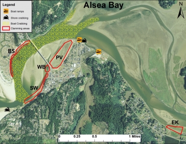
General crab and clam map
Areas
Bayshore (BS)
Multiple access points along clamming area. Gapers and cockles found, but digging can be difficult in soft substrates. Purple varnish clams and softshell clams also occur.
Seawall (SW)
Some gapers can be found, but this area is mainly targeted for harvesting cockles by raking in the sand and into the smaller channel adjacent the seawall (parking and access available at SW Maple Street and Highway 101). Crab by shore using casting gear where there is access to deeper water along the shore.
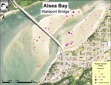
Purple varnish clam bed, east of bridge (PV)
Parking at Alsea Bay Interpretive Center, purple varnish clams found at high densities just east of bridge.
West of Alsea Bridge (WB)
Cockles and gapers may be found in addition to some purple varnish clams. Parking available at Alsea Bay Interpretive Center ().
Eckman Lake (EK)
Softshell clams can be found in many of the muddy areas below the salt marsh. Parking is available along highway 34 directly across from Eckman Lake. This area can be soft and difficult to navigate.
Detailed clamming maps
The ODFW SEACOR project
The ODFW SEACOR project conducts bay clam population and habitat studies in the bays along the coast of Oregon. A primary focus is to document the abundance and preferred habitat of several popular bay clam species. These include butter clams, cockle clams, gaper clams, and native littleneck clams.
SEACOR is funded by recreational shellfish license fees, meaning that clammers and crabbers are directly contributing to research on the resources they enjoy.
To learn more about SEACOR, and find additional detailed clamming maps for Tillamook, Netarts, Siletz, Yaquina, Alsea, and Coos bays, visit the SEACOR web page.
Boat launches
Boat launches in Alsea Bay can be found at the following locations:
The Port of Alsea boat launch
Located off Port St., at the north ends of Broadway and Mill streets, off Hwy 34 (fee applies).
McKinley’s Marina
850 NE Alsea Hwy (Hwy 34) (fee applies).
Information provided is a result of ODFW creel and population surveys, spot checks, and input from local residents. The purpose of this map is to provide the user with information and locations of recreational shellfish areas where the most likelihood of success may be found by species. Clam species identified within a particular area represent the most abundant found; other species may be present or may exist in areas not identified on the map. This is to be used as a reference as sandbars, clam beds, and species composition can shift over time. Always use caution when boating/crabbing in the lower bay as swift currents during tidal exchanges can occur, and result in loss of gear or cause boat to be pulled out to sea if mechanical problems arise. Developed 2014.
Header photo by Alex Derr, Flickr


