Where to crab & clam in Netarts Bay
Clamming is the main attraction in Netarts Bay. The bay is also one of five major crabbing
bays in Oregon with good populations of both Dungeness and redrock crab.

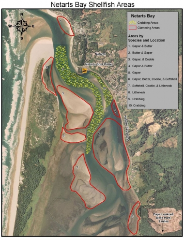
General crab and clam map
Areas
Areas 1 and 4
Can be reached by either boat or bank/walk-in access. These areas are rocky and a garden fork (heavy tined) works best, or a combination of fork and shovel. Beach access to area 1 is found at the end of Crab Ave. in Netarts. This area is dominated by gaper clams though butter clams can also be found. Beach access to area 4 is obtained from Netarts Bay Drive, and is located around the mouth of Rice Creek. This area has a fairly even mix of gaper and butter clams.
Area 2
Requires a boat for access; this is one of the closest areas from the boat basin. This area is sandy and a shovel is best for digging; a clam gun may also be used. This area is dominated by butter clams.
Areas 3 and 5
Large sandy bars and will require a boat for access. Gaper and cockles are the most common species in area 3 with mostly gapers in area 5. Shovels and clam guns will work best for digging gapers, while cockles can be raked or handpicked off the surface.
Area 6
Contains the largest area of sand bars and mud flats along with the widest variety of clam species, though the dominant species will be gaper and butter clams. This area can be reached by either boat or bank/walk-in access. Bank access is obtained from Netarts Bay Drive, both to the north and south of the intersection of Whisky Creek Road and Netarts Bay Drive. Shovels and clam guns will work best for digging in this area.
Area 7
Will require a boat for access. This area is dominated by softshell clams; however, cockle and littleneck clams can also be found. Use a shovel or clam gun for digging.
Area 8
Accessed best by walk-in from the bank; look for small pullouts along Netarts Bay Drive north of the Whisky Creek Fish Hatchery. These mud flats contain a fair amount of littleneck clams. A shovel or rake will work best here.
Area 9
Will require a boat for crabbing. Pots may be set anywhere within this area, but use caution to avoid placing them directly in navigation channels.
Area 10
Can be crabbed from a boat or off the bank using rod and reel set-ups for crab. Bank access is obtained along Netarts Bay Drive, from the boat basin to the mouth of Rice Creek. When placing pots from a boat, avoid direct placement in navigation channels.
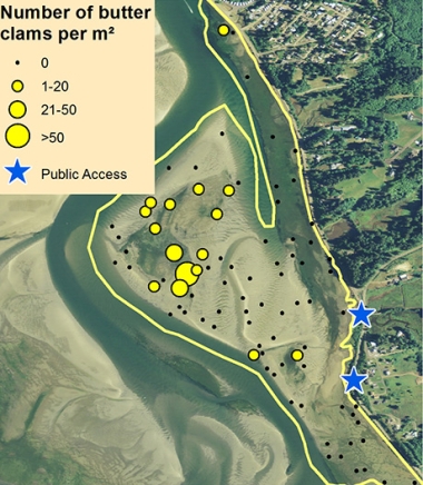
Detailed clamming maps
The ODFW SEACOR project
The ODFW SEACOR project conducts bay clam population and habitat studies in the bays along the coast of Oregon. A primary focus is to document the abundance and preferred habitat of several popular bay clam species. These include butter clams, cockle clams, gaper clams, and native littleneck clams.
SEACOR is funded by recreational shellfish license fees, meaning that clammers and crabbers are directly contributing to research on the resources they enjoy.
To learn more about SEACOR, and find additional detailed clamming maps for Tillamook, Netarts, Siletz, Yaquina, Alsea, and Coos bays, visit the SEACOR web page.
Boat launches
Netarts Boat Basin
Located at the north end of Netarts Bay Drive. The jetties around the boat basin also offer some bank crabbing using rod and reel set-ups.
Information provided is a result of past ODFW surveys, recent spot checks, and input from local residents. The purpose of this map is to provide the user with information and locations of recreational shellfish areas where the most likelihood of success may be found by species. Clam species identified within a particular area represent the most abundant found; other species may be present or may exist in areas not identified on the map. This is to be used as a reference as sandbars, clam beds, and species composition can shift over time. Always use caution when boating/crabbing in the lower bay as swift currents during tidal exchanges can occur, and result in loss of gear or cause boat to be pulled out to sea if mechanical problems arise.
Header photo by Martyne Reesman


