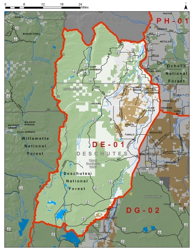
Boundary description
74% public lands. Beginning at Bend; southwest on US Hwy 97 to S Century Dr at MP 153; west on S Century Dr to intersection with Spring Rvr Rd/NF-40; west on Spring Rvr Rd/NF-40 to Deschutes Rvr crossing at Harper Bridge; south (upstream) on the main channel of the Deschutes Rvr to the Wickiup Reservoir Dam; northwest on NF 4260 along Wickiup Dam to S Century Dr/NF 42; west on S Century Dr/NF 42 to Cascade Lakes Scenic Byway; west on NF 4290 to the Pacific Crest Trail (PCT) near Charlton Lk; north on the PCT to the junction of the “crest of the Cascades” with the PCT in T11S R8E Sec 17; north on the Crest of the Cascades to the south boundary of the Warm Springs Tribal Reservation; east on the Warm Springs Tribal Reservation boundary following Je� erson Cr and Metolius Rvr to Lk Billy Chinook; south on Lk Billy Chinook to Crooked Rvr; southeast on the Crooked Rvr to US Hwy 97; south on US Hwy 97 to Bend, point of beginning.
Please review the Big Game Regulations for sub-unit descriptions.
NOTE: This information is for reference use only, and is not intended to replace the information found in the current Big Game Regulations. Please consult the Big Game Regulations before purchasing tags or planning your hunting excursions.