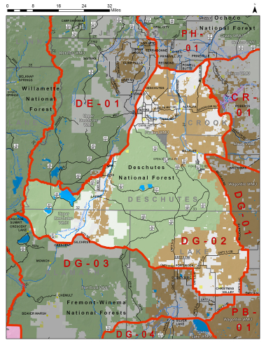
Boundary description
77% public lands. Beginning at Redmond; east on State Hwy 126 to Prineville; southeast on State Hwy 27 to US Hwy 20; west on Hwy 20 to Newt Morris Rd/Fox Butte Rd; south on Fox Butte Rd to Lake Co line; south on Lake Co Rd 5-12D to intersection of Sink Rd (Lake Co Rd 5-12B); east on Sink Rd (Lake Co Rd 5-12B) to intersection of Millican Rd (Lake Co Rd 5-14C); south on Millican Rd (Lake Co Rd 5-14C) to junction of Christmas Valley Hwy (Lake Co Rd 5-14); west on Christmas Valley Hwy (Lake Co Rd 5-14) 13 mi to junction with Fort Rock Rd (Lake Co Rd 5-10); 22 mi north and west on Fort Rock Rd (Lake Co Rd 5-10) to State Hwy 31; northwest on Hwy 31 to NF-2516; south on NF-2516 to NF-9775; west on NF-9775 to US Hwy 97; south on Hwy 97 to Crescent; west on Crescent Cuto� Rd (Klamath Co Rd 61) to State Hwy 58; northwest on Hwy 58 to Paci� c Crest Trail (PCT); north on PCT to NF-4290 near Charlton Lk, east on NF-4290 to Cascade Lakes Scenic Byway; east on S Century Dr/ NF-42 to NF-4260; south on NF-4260 and then east along Wickiup Dam to the Deschutes Rvr; north (downstream) on the main channel of the Deschutes Rvr to the crossing at Harper Bridge with Spring Rvr Rd/ NF-40; east on Spring Rvr Rd/ NF-40 to intersection with S Century Dr; east on S Century Dr to US Hwy 97; northeast on US Hwy 97 to Redmond, point of beginning. (Maps: Deschutes NF, Prineville/Lakeview BLM)
Please review the Big Game Regulations for sub-unit descriptions.
NOTE: This information is for reference use only, and is not intended to replace the information found in the current Big Game Regulations. Please consult the Big Game Regulations before purchasing tags or planning your hunting excursions.