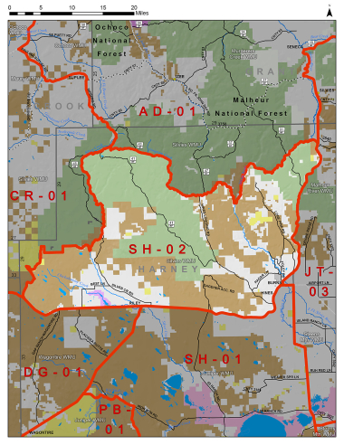
Boundary description
73% public land. Beginning at US Hwy 20/State Hwy 78 Jct in Burns north east on US Hwy 20 to Hwy 395, north on Hwy 395 to FR 3140, west on FR 3140 to Silvies Rvr, southwest on Silvies Rvr to Emigrant Cr, west on Emigrant Cr to FR 47/Hines Logging Rd, south on FR 47/Hines Logging Rd to FR43, west on FR 43 to FR 4370, west on FR 4370 to FR 41, west on FR 41 to FR 45, west on FR 45 to Silver Cr, south on Silver Cr to Nicoll Cr, west on Nicoll Cr to Malheur National Forest boundary, east on the Malheur National Forest boundary to Bulger Cr, southwest on Bulger Cr to Bulger Cr Rd, southeast on Bulger Cr Rd to Potato Hills Rd (BLM Rd #7241-00), southwest on Potato Hills Rd to Hwy 20, east on Hwy 20 to Hwy 78 in Burns, the point of beginning.
Please review the Big Game Regulations for sub-unit descriptions.
NOTE: This information is for reference use only, and is not intended to replace the information found in the current Big Game Regulations. Please consult the Big Game Regulations before purchasing tags or planning your hunting excursions.