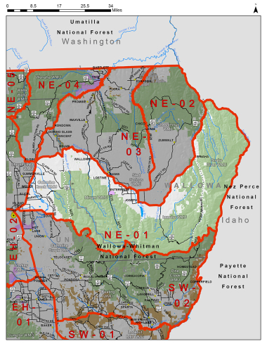
Boundary description
72% public lands. Beginning at confluence of Imnaha and Snake Rvr; southeast on Snake Rvr to � thirty-two Point Cr; southwest on � thirty-two Point Cr to Summit Rd; southwest and northwest on Summit Rd to FR 3965; south on FR 3965 then west to Upper Crazyman Trailhead; south from Upper Crazyman Trailhead along Summit Ridge; west from Summit Ridge to FR 3962 (N Fork Dry Cr); southwest on N Fork Dry Cr and northwest on Dry Cr to Imnaha Rvr; south and west on Imnaha Rvr and S fork of Imnaha Rvr to Hawkins pass; northwest from Hawkins pass past Eagle Cap and Horton Pass; south from ridgeline past Frazier Pass, Needle Point, and Arrow Lk to Granite Butte; northwest on summit separating Big Minam and Catherine Cr drainages past Burger Butte and Meadow Mt to Cartwheel Ridge Trail 1907; west on Cartwheel Ridge Trail to Lodgepole Trail 1920; north on Lodge Pole Trail to Moss Springs campground; west on Mill Cr Rd to Cove; west on Hwy 237 to Island City; northeast on Hwy 82 to Elgin; northeast on Hwy 82 to Minam; south east on Hwy 82 to Joseph; northeast on Imnaha Hwy to Imnaha; north on Imnaha Rvr to confluence of Imnaha and Snake Rvr, point of beginning.
Hunt Maps within this Hunt Area
NE101-2 Late Wallowa Valley Whitetail Map
NE601 Wallowa Valley Antlerless Whitetail map
Please review the Big Game Regulations for sub-unit descriptions.
NOTE: This information is for reference use only, and is not intended to replace the information found in the current Big Game Regulations. Please consult the Big Game Regulations before purchasing tags or planning your hunting excursions.