
Search myodfw.com
Showing 281 - 300 of 1415 results

Find maps, boundary descriptions and the percent public land for the Mt. Emily Unit.
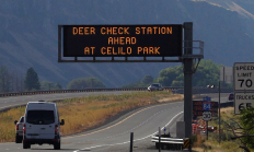
SALEM, Ore.—As 2025 deer and elk hunting seasons begin, ODFW is ramping up its Chronic Wasting Disease (CWD) surveillance statewide. Hunters are encouraged to take advantage of streamlined testing options and reminded that CWD check stations are mandatory to stop at when transporting harvested deer or elk. Sampling is quick…
Find maps, boundary descriptions and the percent public land for the Keno Unit.
Find maps as well as boundary and percent public land for the Grizzly Unit.
Find maps, boundary descriptions and the percent public land for the Snake River Unit.
Find maps, boundary descriptions and the percent public lands for the Desolation Unit.
Find maps, boundary descriptions and the percent public land for the Wilson Unit.
Find maps, boundary descriptions and the percent public land for the Klamath Falls Unit.
Find maps, boundary descriptions and the percent public land for the Pine Creek Unit.
Find maps, boundary descriptions and the percent public land for the Interstate Unit.
Find maps, boundary descriptions and the percent public land for the Santiam Unit.

Find maps as well as boundary and the percent public land for the Metolius Unit.
SALEM, Ore. – ODFW and the Oregon Hunters Association (OHA) will give away free wildlife forage seed to landowners at E.E. Wilson Wildlife Area near Corvallis on Saturday, May 9. The giveaway coincides with OHA's Youth Field Day (limited spots available). Seed giveaway More than 500 bags of free seed…
Find maps, boundary descriptions and the percent public lands for the Northside Unit.
Find maps, boundary information and the percent public land in the Chetco Unit.
Find maps, boundary descriptions and the percent public land for the Keating Unit.
Find maps, boundary descriptions and the percent public lands in the Ukiah Unit.
Find maps, boundary descriptions and hunts available in the new Mid Columbia Hunt Area. Download printable PDF map
Find maps, boundary descriptions and the percent public land in the Biggs Unit.