
Search myodfw.com
Showing 281 - 300 of 1410 results
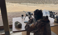
This hands-on course is designed for adults eager to enter (or advance in) big game hunting with a modern, scoped bolt-action rifle—the most popular and precise choice for ethical big game pursuits.
July
Big Timber Rifle and Pistol Club 158 WADE RD SILETZ, OR 97380-9742
Find maps, boundary descriptions and the percent public land for the Mt. Emily Unit.
Find maps, boundary information and the percent public land in the Applegate Unit.
Find maps, boundary information and the percent public land for the Maupin Unit.
Find maps, boundary descriptions and the percent public land for the Warner Unit.

Find maps, boundary descriptions and the percent public land for the Columbia Basin Unit.
Find maps, boundary descriptions and the percent public land for the Interstate Unit.
Find maps, boundary descriptions and the percent public land for the Klamath Falls Unit.
Find maps, boundary descriptions and the percent public land for the Wilson Unit.

Greater sage-grouse are best known for their elaborate courtship displays that occur on traditional strutting grounds, known as leks, where males gather each spring. At all seasons, both sexes are readily identified by large size and chicken-like build. Adults are mottled dark gray, black and buff, with black bellies and pointed tails. Males have specializations used in display. Their tail feathers are long and pointed with white spots. They have yellow combs over each eye and a chest sac with two bare, yellow patches of skin which are inflated during display. The display lasts only a few seconds and is…

Find maps as well as boundary and the percent public land for the Metolius Unit.
Find maps, boundary information and the percent public land in the Evans Creek Unit.
Find maps, boundary information and the percent public land in the Ochoco unit.
Find maps, boundary information and the percent public land in the Tioga Unit.
Find maps, boundary information and the percent public land in the Rogue Unit.
Find maps, boundary descriptions and the percent public land for the Chesnimnus Unit.
Cattle egrets are the smallest of Oregon's three egret species, with short, stout neck and legs, and white body with orange-buff plumes on the head and nape in spring and early summer. They are named for their association with livestock, consuming insects on their backs or stirred up by their hooves. In Oregon, the Cattle egret is a casual transient in spring in the Klamath Basin and rarely in the Malheur National Wildlife Refuge. The least widespread of the state's egrets during the breeding season; a rare breeder in the Great Basin and a few pairs occasionally nesting at Malheur…

The nasal meow of the Franklin's gull can be heard as it soars above wetlands and meadows, and colonies of this species are reported to be the loudest of all the gulls. In breeding plumage, the black hood contrasts sharply with the white breast and bright red bill. This species depends much more on insects and other invertebrates than do other gulls, and is therefore considered economically beneficial and favored by farmers. The Franklin's gull occurs in the southeast portion of the state in spring and summer, especially Harney Basin. It is rare west of the Cascades. It nests locally…
