Search myodfw.com
Showing 341 - 360 of 1410 results
Landing page
Find maps, boundary descriptions and the percent public land for the Snake River Unit.
September 05, 2017
Article
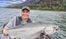
Fishing isn’t hard, but it can be confusing to know how to begin. Here’s a step-by-step approach to get from thinking about it to doing it.
April 15, 2026

Landing page
Find maps, boundary descriptions and the percent public land for the Beulah Unit.
September 05, 2017
Landing page
Find maps, boundary descriptions and the percent public land for the Steens Mountain Unit.
September 05, 2017
Article
Salmon, steelhead and smallmouth bass offer world-class fishing here year-round. Rainbow trout are stocked in the upper Rogue and in lakes nestled in settings as varied as fir forest and wind-swept dune. Big reservoirs provide fishing for trout and for thriving populations of largemouth bass, catfish, perch and crappie. Coastal bays serve as gateways to rich offshore reef fisheries, and miles of public beach welcome anglers to fish for surfperch against a backdrop of rugged capes.

Landing page
Find maps, boundary descriptions and the percent public land for the Wagontire Unit.
September 05, 2017
Landing page
Find maps, boundary descriptions and the percent public land for the Saddle Mountain Unit.
September 05, 2017

Zones or Areas
This vast area covers the Columbia Basin through the Blue, Wallowa and Elkhorn mountains to the Snake River.
Landing page
Find maps, boundary information and the percent public land in the Paulina Unit.
September 05, 2017
Landing page
Find maps, unit descriptions and the percent public lands in the Starkey Unit.
September 05, 2017
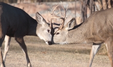
Article
Over-winter survival was generally good for Oregon's deer and elk herds. Parts of the state even got a reprieve from years-long drought this spring but dry conditions came back in late summer and fall, and big game body condition heading into the fall season will vary by district. See the district reports for details on what to expect. Get your animal tested for CWD: While it's never been found in Oregon, CWD has been detected in most surrounding states and animals can carry the disease (and spread it) for years without showing symptoms. By getting your deer or elk tested…
September 2, 2025
Landing page
Find maps, boundary descriptions and the percent public land for the Trask Unit.
September 05, 2017
Landing page
Find maps, boundary descriptions and the percent public land for the Santiam Unit.
September 05, 2017

Zones or Areas
Wide open spaces, wild windy places, and extreme temperatures characterize Oregon’s largest, most remote fishing zone. Redband trout are native to its rivers and streams, including the Williamson, Malheur and Chewaucan. Brown and hatchery rainbow trout can grow to trophy-size in many of its lakes and reservoirs, many of which also feature crappie, yellow perch and bass.

Article
With just a couple of tools and a few minutes, The Fish Grip™, originally designed as a safer way for anglers to land fish, can easily be converted into a rockfish descending device. Fish Grips™ can be purchased at local tackle shops or online.

Landing page
Find maps, boundary descriptions and the percent public land for the Sled Springs Unit.
September 05, 2017
Article
Bass are an increasingly popular game fish even in a state noted for its native salmon, steelhead and trout. Bass often thrive in the urban waters of places like the Willamette Valley where warmer temperatures limit trout fishing in the summer months. Whether you target them in the Columbia or Willamette rivers, a coastal lake or the neighborhood pond, throughout much of the year bass can offer a rewarding fishing opportunity relatively close to home.
October 27, 2025

Educational Moment
Tucker Jones, Ocean Salmon and Columbia River Program Manager Summary of 2024 Fisheries and Outlook for 2025 Fisheries The Columbia River Management section of OSCRP has posted a document to the ODFW website with preliminary estimates of 2024 salmon returns and fishery results, 2025 run forecasts for spring Chinook, summer Chinook, and sockeye salmon, as well as a list of currently-known key dates for 2025 fisheries planning milestones. This document is prepared jointly by the ODFW and WDFW Columbia River fishery management staffs each year. This useful document has a table of salmonid returns/forecasts that will be updated on our…
February 25, 2025