Search myodfw.com
Showing 361 - 380 of 815 results
Find maps, boundary descriptions and the percent public land for the Silver Lake Unit.
Find maps, boundary descriptions and the percent public land for the Willamette Unit.
Find maps, boundary descriptions and the percent public land for the Lookout Mountain Unit.
Find maps, boundary descriptions and the percent public land for the Wagontire Unit.
Find maps, boundary descriptions and the percent public land for the Silvies Unit.
Find maps, boundary descriptions and the percent public land for the Beulah Unit.
Find maps, boundary descriptions and the percent public land for the Melrose Unit.
Find maps, boundary information and the percent public land in the Paulina Unit.
Find maps, unit descriptions and the percent public lands in the Starkey Unit.
Find maps, boundary descriptions and the percent public land for the Saddle Mountain Unit.

Find maps, boundary descriptions and percent public land for the Murderers Creek Unit.
Find maps, boundary information and the percent public land in the Chetco Unit.
Find maps, boundary descriptions and the percent public land for the Santiam Unit.

Find maps, boundary descriptions and the percent public land for the Sled Springs Unit.
Find maps, boundary descriptions and the percent public land for the Indigo Unit.
SALEM, Ore. – The Oregon Department of Fish and Wildlife is accepting applications for the Chair position on the state Access & Habitat (A&H) Program Board. The deadline to apply is April 3, 2026. Application forms and additional information are available at: http://www.dfw.state.or.us/lands/AH/get_involved.asp The current Chair has completed the maximum…
Find maps, boundary descriptions and the percent public land for the Fort Rock Unit.
The FRWA was created by a licensing agreement signed in 1957 and modified in 1982 and 2008, between the US Army Corps of Engineers and the Oregon Game Commission. This agreement authorized the state to develop, conserve, and manage all wildlife resources on 5,261 acres of land and water within the Fern Ridge Project. ODFW also acquired the 309 acre Coyote Creek South and 224 acre Coyote Creek Northeast units in 2013 and 2015, respectively. The wildlife area now totals 5,794 acres.
Lower Deschutes Wildlife Area was established in 1983, with the initial donation of land by the Oregon Wildlife Foundation (OWF) of 2,758 acres. In 1986 OWHF donated an additional 5,158 acres of land to the department. The Lower Deschutes Wildlife Area was initially established to provide permanent public angler access. However, especially with the 1986 acquisition, the wildlife area has grown to provide enhanced wildlife and fish habitat (i.e. through removal of livestock, riparian vegetation improvements, etc.) and more wildlife-oriented recreational activities such as hunting, boating, hiking and biking. In 2015, ODFW partnered with the Trust for Public Land to…
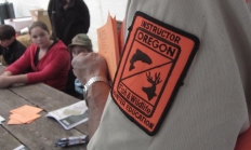
Oregon requires all hunters under the age of 18 to complete a hunter safety education course before hunting in the state. Upon completing the course (and a Field Day for youth), participants will receive a Hunter Safety certification number and card. Adults are also encouraged to take the online course, as it may be required for out of state hunts. Note: Youth under the age of 9 may struggle with the course material and may not have the physical strength needed to safely handle a firearm during a Field Day, particularly during muzzle control, loading, and unloading drills.
Offered Year Round
Statewide