Search myodfw.com
Showing 381 - 400 of 714 results
Lower Deschutes Wildlife Area was established in 1983, with the initial donation of land by the Oregon Wildlife Foundation (OWF) of 2,758 acres. In 1986 OWHF donated an additional 5,158 acres of land to the department. The Lower Deschutes Wildlife Area was initially established to provide permanent public angler access. However, especially with the 1986 acquisition, the wildlife area has grown to provide enhanced wildlife and fish habitat (i.e. through removal of livestock, riparian vegetation improvements, etc.) and more wildlife-oriented recreational activities such as hunting, boating, hiking and biking. In 2015, ODFW partnered with the Trust for Public Land to…
White River Wildlife Area was established in 1953. Located along the east slope of the Cascade Mountains in the north central part of Oregon, the wildlife area encompasses 29,480 acres. An additional 1,280 acres of land owned by the Bureau of Land Management (BLM) is managed by the ODFW bringing the total acres managed by the department to 30,760. The primary purpose of White River Wildlife Area is to provide winter range habitat for black-tailed deer and Rocky Mountain elk and to minimize big game damage to adjacent private agricultural lands.
This 141-acre property along both sides of the Yachats River was first purchased in the early 1980s to provide forage for elk and help alleviate elk damage to surrounding agricultural land. It also provides public access to the Siuslaw National Forest along the Yachats River Highway, where there are few public access points.
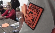
Oregon requires all hunters under the age of 18 to complete a hunter safety education course before hunting in the state. Upon completing the course (and a Field Day for youth), participants will receive a Hunter Safety certification number and card. Adults are also encouraged to take the online course, as it may be required for out of state hunts. Note: Youth under the age of 9 may struggle with the course material and may not have the physical strength needed to safely handle a firearm during a Field Day, particularly during muzzle control, loading, and unloading drills.
Offered Year Round
Statewide
Located near the Elkhorn Mountain Range, Elkhorn Wildlife Area is best known for Rocky Mountain elk and mule deer herds that use the area during the winter. To keep deer and elk from feeding on agriculture lands when they come down from snow-covered higher elevations, ODFW operates 10 feeding sites on the area to feed 1,400 elk and 800 deer during the winter months.
NW WILDLIFE VIEWING June 18, 2026 Tillamook County Birds Large numbers of waterfowl have moved back to spring nesting grounds. They will raft up out in the middle of most local estuaries on calm days but will move around with the incoming tide and on windy days. Many species of diving ducks can be seen on area lakes and bays. Likewise, many migrating geese are beginning to arrive and are using area fields, along with many egrets, herons and wintering raptors. Pastures and fields are heavily used by a variety of waterfowl when flooded and by wading birds under nearly…
SE WILDLIFE VIEWING June 18, 2026 Harney County With warmer temperatures occurring throughout Harney County various orders of birds can be viewed including but not limited to Passeriformes, Galliformes, Accipitriformes, and Anseriformes. The county experienced a mild winter this season making for low snowpack accumulation even at higher elevations, access for observation opportunities should be good even early this summer. Although, those looking to explore rural areas of the county should keep recovery items in their vehicle. Early summer rains occurring periodically may cause muddy conditions on unpaved roads. With the late spring months comes wildlife baby season. Most wildlife…
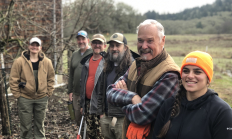
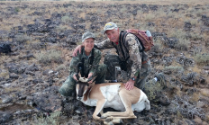
Oregon's diverse habitats and terrain offers something for every hunter. From the densely forested Coast Range to the expansive sage steppe of the Great Basin, hunting opportunities are practically unlimited. Visit e-regulations


The Columbia Basin Wildlife Areas are a composition of four Oregon Department of Fish and Wildlife (department) managed wildlife areas located along the Columbia River, in the Columbia Basin. The four wildlife areas (Power City, Irrigon, Coyote Springs and Willow Creek) are within the Columbia Plateau ecoregion. Management agreements for these areas were initially established between 1971 and 1977 between the department and Federal agencies which own the lands. The Columbia Basin Wildlife Areas, which total approximately 1,885 acres, provide an important landbase for the conservation and recreation of fish and wildlife within a highly privatized and altered landscape and…

When you sign up to be an ODFW volunteer, you're helping to protect Oregon's fish and wildlife, manage ODFW properties, and share your hunting and fishing experiences with others while creating a stronger appreciation for the outdoors. Already volunteering with ODFW
Year round opportunities
Various programs statewide