
Search myodfw.com
Showing 101 - 120 of 226 results
Find maps, boundary descriptions and the percent public land for the McKenzie Unit.
Find maps, boundary descriptions and the percent public land for the Owyhee Unit.
Find maps, boundary descriptions and the percent public land for the Walla Walla Unit.
Find maps, boundary descriptions and the percent public lands for the Desolation Unit.
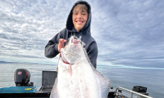
NEWPORT, Ore. – The Oregon Department of Fish and Wildlife is hosting a Feb. 2 public meeting beginning at 6 p.m. to get input on the number and timing of fixed and back-up dates for the central Oregon coast spring all-depth Pacific halibut season. The meeting is in the conference…
CENTRAL WILDLIFE VIEWING April 9, 2026 Crook County Spring ungulate migration will soon be upon us. You can find mule deer transitioning from low elevation winter feeding areas to the higher elevation sagebrush and agricultural areas. There are red-tailed, rough-legged and ferruginous hawks, northern harriers, American kestrels, prairie falcons and golden eagles throughout Crook County and they're usually associated more closely with open/agricultural areas. Bald eagles and ospreys, on the other hand, are more closely associated with water bodies. Look for northern goshawks throughout the Ochoco National Forest, and for ducks and geese in rivers and lakes. Prineville Reservoir Wildlife…
Willamette Trout Hatchery and the adjacent Oakridge Salmon Hatchery were combined in 1983 and operate today as Willamette Hatchery. The trout hatchery was constructed in 1922 and the salmon hatchery in 1911. The U.S. Army Corps of Engineers (USACE) rebuilt the salmon hatchery in 1952 to mitigate for fishery losses caused by Hills Creek, Lookout Point and the Dexter hydroelectric/flood control projects. The trout side was rebuilt between 1950 and ‘56. Today, Willamette Hatchery is used for adult holding/spawning, egg incubation and rearing of spring Chinook and rainbow trout. In addition, both summer and winter steelhead are reared at this…
Oak Springs Hatchery was constructed in several phases beginning in 1922 with the last major construction in 1996. The facility is currently used for egg production, incubation and rearing of rainbow trout, incubation and rearing of summer and winter steelhead, and maintains one resident rainbow trout and one resident cutthroat broodstock.
Find maps, boundary descriptions and the percent public land for the Keno Unit.
The McKenzie River originates in the Cascade Range and empties into the Willamette River near Eugene, which then flows northward into the Columbia River. McKenzie Hatchery was first constructed in 1938 and rebuilt in 1975. Today, 30 rearing ponds, a visitor's center, spawning room, egg incubation facility, office, feed storage, shop area, fish ladder and picnic area are the main components of the facility layout. McKenzie Hatchery is temporarily closed to comply with Oregon Department of Environmental Quality permit conditions. Visitors should be aware that no fish are present in the facilities' production raceways and show ponds. Fish have been…
Find maps as well as boundary and the percent public land for the Metolius Unit.
Find maps, boundary descriptions and the percent public lands for the Northside Unit.
Find maps, boundary descriptions and the percent public land for the Pine Creek Unit.
Find maps, boundary descriptions and the percent public land for the Sprague unit.
Find maps, boundary descriptions and the percent public lands in the Ukiah Unit.
Find maps, boundary descriptions and the percent public land for the Interstate Unit.
Find maps, boundary descriptions and the percent public land for the Keating Unit.
Find maps, boundary descriptions and the percent public land for the Klamath Falls Unit.
Find maps, boundary descriptions and the percent public land for the Wilson Unit.