

Search myodfw.com
Showing 181 - 200 of 396 results
Recreation Report
SW WILDLIFE VIEWING May 14, 2026 Coos and Curry counties Coquille Valley Wildlife Area (CVWA) Coquille Valley Wildlife Area (CVWA) in Coos County is open to public access. Permits for access are required and are available, free of charge, at the kiosk located in the parking lot along North Bank Road. You must access CVWA through this point. Please fill out the upper half ("A" half) of the permit and deposit it in the slot located on the post of the kiosk. Sign and carry the lower half ("B" half) with you while you enjoy CVWA. At the end of…
September 05, 2017
Press Release
ASTORIA, Ore – The annual conservation closure of razor clamming on Clatsop beaches begins 12:01 a.m. July 15. The Oregon Department of Fish and Wildlife encourages clammers to take advantage of the low tide series that begins July 8. However, ODFW reminds clammers that although the low tide series goes…
July 7, 2025
Press Release
FOR IMMEDIATE RELEASE Oregon Department of Fish and Wildlife (ODFW) Confederated Tribes of the Umatilla Indian Reservation (CTUIR) Statement on Qapqápa Wildlife Area Acquisition Oregon Department of Fish and Wildlife (ODFW) and the Confederated Tribes of the Umatilla Indian Reservation (CTUIR) regret to announce that the Qapqápa (pronounced cop-COP-a) Wildlife…
March 2, 2026
Landing page
The original Riverside Tract is adjacent to the Malheur River near the former railroad community of Riverside. It was purchased from the Blaylock family in 1976 and has been administered by ODFW as Riverside Wildlife Area since that time. The purpose of this initial acquisition was to provide public fishing and hunting access to a previously privately held portion of the Malheur River canyon. In addition, this purchase provided the opportunity for the department to emphasize fish and wildlife habitat management in the river canyon. Additional acres were added to this tract in 1977. In 1972, the department purchased a…
February 12, 2018
Zones or Areas
Trout fishing opportunities abound in this zone, known for its high desert climate, sage-covered canyons, glacial peaks and mountain lakes. Anglers will find year-round trout fishing in the Deschutes, Metolius, Fall and Crooked rivers, while several central Oregon lakes and reservoirs are renowned for their trout and kokanee fishing – and their beauty. The Hood and lower Deschutes – both tributaries of the Columbia River – offer high desert fishing for Chinook salmon and summer steelhead.
Landing page
Find maps, boundary descriptions and hunts available in the new Northeast Hunt Area. Download printable PDF map
November 15, 2025
Landing page
Find maps, boundary descriptions and hunts available in the new Devils Garden Hunt Area. Download printable PDF map
November 13, 2025
Landing page
Find maps, boundary descriptions and hunts available in the new Northeast Hunt Area. Download printable PDF map
November 15, 2025
Zones or Areas
The granite peaks of Oregon’s Blue and Wallowa Mountains form the backdrop for many of this zone’s glacier-carved lakes and crystalline streams. Bull trout thrive in this zone’s cold, clear rivers, which also sustain whitefish and rainbow trout, and welcome returning runs of hatchery-reared steelhead. Chinook salmon travel over 300 miles up the Columbia to spawn in rivers such as the Imnaha and Wallowa. Warmwater fisheries are few, but the John Day River offers world-class fishing for smallmouth bass.
Zones or Areas
Abundant rainfall feeds the massive Willamette River watershed, tamed by a system of reservoirs that are stocked annually with hundreds of thousands of rainbow trout. Some of these reservoirs also grow trophy-size largemouth and smallmouth bass, as well as bluegill, brown bullhead and crappies. Smaller lakes and ponds nearer the valley floor provide springtime trout fishing close to home. Salmon and steelhead navigate the Willamette River and its tributaries, many of which are also home to rainbow and cutthroat trout.
Zones or Areas
Wide open spaces, wild windy places, and extreme temperatures characterize Oregon’s largest, most remote fishing zone. Redband trout are native to its rivers and streams, including the Williamson, Malheur and Chewaucan. Brown and hatchery rainbow trout can grow to trophy-size in many of its lakes and reservoirs, many of which also feature crappie, yellow perch and bass.
Landing page
Find maps, boundary descriptions and hunts available in the new South Wallowa Hunt Area. Download printable PDF map
November 15, 2025
Article
Resuming in 2022, successful bear hunters must appear in-person at an ODFW office to check in their bear's skull.

Landing page
The E.E. Wilson Wildlife Area came into existence in 1950 when the U.S. Government gave quitclaim title to the property to the Oregon Department of Fish and Wildlife. The wildlife area covers approximately 1,788 acres, is located on Highway 99W about 10 miles north of Corvallis and is situated on the Willamette Valley floor. SHOTGUN RANGE BACK OPEN AS OF LATE OCTOBER 2025: The renovation is complete and the shotgun range is back open. Improvements include: four times as many shooting lanes, fully paved ADA-compliant walkway with pullouts that will make it easier for disabled shooters, a new covered pole…
February 07, 2018
Landing page
Find maps, boundary descriptions and hunts available in the new Trout Creek Hunt Area. Download printable PDF map
November 15, 2025
Site Sections
Article
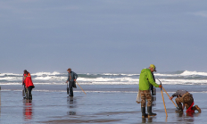
The areas around Bandon, on the Coquille River, have productive softshell beds. The areas near Bandon Marsh National Wildlife Refuge tend to be the most popular. Populations of other bay clams may be found close to the jettys but are mostly subtidal.

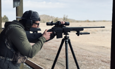
Workshop and Events
This is a one-day training course designed for hunters who want to shoot farther when conditions and skill allow. This course emphasizes ethical shot execution and practical field positions with mid-to-long range targets.
Date
May & June
Location
Multiple locations
Landing page
Find maps, boundary descriptions and hunts available in the new Jackknife Hunt Area. Download printable PDF map
November 14, 2025
Landing page
Find maps, boundary descriptions and hunts available in the new North Blues Hunt Area. Download printable PDF map
November 15, 2025