
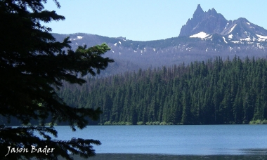
Fishing
Weekly trout stocking schedule
Each year, ODFW stocks millions of trout in dozens of reservoirs, lakes and ponds throughout the state. You can use the search and filter functions to search the stocking schedule for specific locations and dates. The schedule is subject to change without notice; see individual waterbody listings in the Recreation Report for updates.
The schedule shows the WEEK a waterbody will be stocked, not the exact date. The Monday dates listed indicate the START of the week.
There can be changes to the stocking schedule
Some waterbodies may not be stocked as scheduled because of poor water conditions, and these fish will be diverted to another location. In other cases, stocking may happen a week before/after the scheduled date due to logistical challenges. Staff may need to make these decisions quickly, and not have time to update the stocking database.
Please check the weekly Recreation Report for any changes to the stocking schedule.
Find your way to stocking locations
Stocking Schedule
| Week of | Waterbody | Zone/Office | Legals | Trophy | Brood | Total |
|---|---|---|---|---|---|---|
| - | LEABURG LK | Willamette / Springfield | 1,000 | 0 | 0 | 1,000 |
| - | FALL R | Central / Bend | 0 | 1,000 | 0 | 1,000 |
| - | DEVILS LK | Central / Bend | 1,384 | 0 | 0 | 1,384 |
| - | BREITENBUSH R | Willamette / Corvallis | 2,000 | 0 | 0 | 2,000 |
| - | ALTON BAKER CANAL | Willamette / Springfield | 900 | 0 | 0 | 900 |
| - | BADGER LK | Central / The Dalles | 650 | 0 | 0 | 650 |
| - | SANTIAM R, N FK-2 | Willamette / Corvallis | 2,200 | 0 | 0 | 2,200 |
| - | ALTON BAKER CANAL | Willamette / Springfield | 900 | 0 | 0 | 900 |
| - | ROGUE R above Lost Creek | Southwest / Central Point | 2,500 | 0 | 0 | 2,500 |
| - | MCKENZIE R-2 (above Leaburg Dam) | Willamette / Springfield | 850 | 0 | 0 | 850 |
| - | LEABURG LK | Willamette / Springfield | 1,000 | 0 | 0 | 1,000 |
| - | SALMON CR | Willamette / Springfield | 667 | 0 | 0 | 667 |
| - | MCKENZIE R-1 (below Leaburg Dam) | Willamette / Springfield | 2,000 | 0 | 0 | 2,000 |
| - | ALTON BAKER CANAL | Willamette / Springfield | 900 | 0 | 0 | 900 |
| - | ROGUE R above Lost Creek | Southwest / Central Point | 2,500 | 0 | 0 | 2,500 |
| - | FARADAY LK | Willamette / Clackamas | 1,334 | 0 | 0 | 1,334 |
| - | CLEAR LK | Willamette / Springfield | 3,000 | 0 | 0 | 3,000 |
| - | CULTUS LK, B | Central / Bend | 2,500 | 0 | 0 | 2,500 |
| - | ESTACADA LK | Willamette / Clackamas | 1,334 | 0 | 0 | 1,334 |
| - | MCKENZIE R-2 (above Leaburg Dam) | Willamette / Springfield | 2,500 | 0 | 0 | 2,500 |
| - | SMALL FRY LK | Willamette / Clackamas | 200 | 0 | 0 | 200 |
| - | NORTH FORK RES | Willamette / Clackamas | 5,134 | 0 | 0 | 5,134 |
| - | SHEVLIN PD | Central / Bend | 666 | 0 | 0 | 666 |
| - | METOLIUS PD | Central / Bend | 300 | 0 | 0 | 300 |
| - | ESTACADA LK | Willamette / Clackamas | 1,334 | 0 | 0 | 1,334 |
| - | NORTH FORK RES | Willamette / Clackamas | 11,134 | 0 | 0 | 11,134 |
| - | ALTON BAKER CANAL | Willamette / Springfield | 900 | 0 | 0 | 900 |
| - | LEABURG LK | Willamette / Springfield | 1,000 | 0 | 0 | 1,000 |
| - | TRILLIUM LK | Willamette / Clackamas | 2,000 | 333 | 0 | 2,333 |
| - | ROGUE R above Lost Creek | Southwest / Central Point | 2,500 | 0 | 0 | 2,500 |
| - | FARADAY LK | Willamette / Clackamas | 1,334 | 0 | 0 | 1,334 |
| - | SMALL FRY LK | Willamette / Clackamas | 200 | 0 | 0 | 200 |
| - | HARRIET LK | Willamette / Clackamas | 2,000 | 667 | 0 | 2,667 |
| - | SMALL FRY LK | Willamette / Clackamas | 134 | 0 | 0 | 134 |
| - | TWIN LK, N | Central / Bend | 0 | 500 | 0 | 500 |
| - | ESTACADA LK | Willamette / Clackamas | 800 | 0 | 0 | 800 |
| - | MCKENZIE R-1 (below Leaburg Dam) | Willamette / Springfield | 2,000 | 0 | 0 | 2,000 |
| - | NORTH FORK RES | Willamette / Clackamas | 2,334 | 0 | 0 | 2,334 |
| - | ROGUE R above Lost Creek | Southwest / Central Point | 2,500 | 0 | 0 | 2,500 |
| - | TWIN LK, S | Central / Bend | 0 | 500 | 0 | 500 |
| - | FARADAY LK | Willamette / Clackamas | 800 | 0 | 0 | 800 |
| - | TOWN LK | Northwest / Tillamook | 0 | 300 | 0 | 300 |
| - | FALL R | Central / Bend | 0 | 1,000 | 0 | 1,000 |
| - | WALTON LK | Central / Bend | 0 | 750 | 0 | 750 |
| - | COFFENBURY LK | Northwest / Tillamook | 0 | 500 | 0 | 500 |
| - | LOST LK | Northwest / Tillamook | 0 | 300 | 0 | 300 |
| - | CAPE MEARES LK | Northwest / Tillamook | 0 | 300 | 0 | 300 |
| - | ALTON BAKER CANAL | Willamette / Springfield | 900 | 0 | 0 | 900 |
| - | MCKENZIE R-2 (above Leaburg Dam) | Willamette / Springfield | 2,000 | 0 | 0 | 2,000 |
| - | SUNSET LK (N COAST RANGE) | Northwest / Tillamook | 0 | 150 | 0 | 150 |
Explore Related Articles
Where to fish
Each year ODFW stocks millions of trout in dozens of reservoirs, lakes and ponds across the state.
Finding these locations...

How to fish
More people in Oregon fish for trout than for any other kind of fish. Anglers can experience a lifetime of...
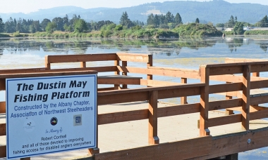
Where to fish
Many of the more popular fishing locations across the state are accessible to anglers with disabilities. ODFW tries to keep...