
Search myodfw.com
Showing 361 - 380 of 714 results
Find maps, boundary descriptions and percent public land for the Fossil Unit.
Find maps, boundary descriptions and the percent public land for the Silver Lake Unit.
Find maps, boundary descriptions and the percent public land for the Willamette Unit.
Find maps, boundary descriptions and the percent public land for the Lookout Mountain Unit.
Find maps, boundary descriptions and the percent public land for the Wagontire Unit.
Find maps, boundary descriptions and the percent public land for the Silvies Unit.
Find maps, boundary descriptions and the percent public land for the Beulah Unit.
Find maps, boundary descriptions and the percent public land for the Melrose Unit.
Find maps, boundary information and the percent public land in the Paulina Unit.
Find maps, unit descriptions and the percent public lands in the Starkey Unit.
Find maps, boundary descriptions and the percent public land for the Saddle Mountain Unit.

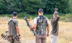
Our Mission The Oregon Department of Fish and Wildlife (ODFW) Hunter Recruitment Program is dedicated to strengthening and growing Oregon's hunting and shooting sports community. We provide hands-on skills training, promote a culture of safety, ethics, and conservation, and foster a positive public perception of hunting and shooting sports. Our goal is to build confidence, knowledge, and skills for both new and seasoned hunters, supporting a lasting connection to Oregon's rich outdoor traditions. Workshops are offered statewide throughout the year. View and register for an upcoming event: Classes and W or kshops.
Find maps, boundary descriptions and percent public land for the Murderers Creek Unit.
CENTRAL WILDLIFE VIEWING June 18, 2026 Crook County Spring ungulate migration will soon be upon us. You can find mule deer transitioning from low elevation winter feeding areas to the higher elevation sagebrush and agricultural areas. There are red-tailed, rough-legged and ferruginous hawks, northern harriers, American kestrels, prairie falcons and golden eagles throughout Crook County and they're usually associated more closely with open/agricultural areas. Bald eagles and ospreys, on the other hand, are more closely associated with water bodies. Look for northern goshawks throughout the Ochoco National Forest, and for ducks and geese in rivers and lakes. Prineville Reservoir Wildlife…
Find maps, boundary information and the percent public land in the Chetco Unit.
Find maps, boundary descriptions and the percent public land for the Santiam Unit.

Find maps, boundary descriptions and the percent public land for the Sled Springs Unit.
Find maps, boundary descriptions and the percent public land for the Indigo Unit.
SALEM, Ore. – The Oregon Department of Fish and Wildlife is accepting applications for the Chair position on the state Access & Habitat (A&H) Program Board. The deadline to apply is April 3, 2026. Application forms and additional information are available at: http://www.dfw.state.or.us/lands/AH/get_involved.asp The current Chair has completed the maximum…
Find maps, boundary descriptions and the percent public land for the Fort Rock Unit.