
Search myodfw.com
Showing 381 - 400 of 777 results
Find maps, boundary descriptions and the percent public land for the Dixon Unit.
Features: Redear sunfish are often confused with bluegill, but differ by having a red or orange border around the black ear flap and by lacking the spot on the dorsal fin and the vertical bars on the side. Habitat: In Oregon, redear sunfish are found only in a few ponds in the Willamette Valley and the central part of the state. In their native range, redear sunfish prefer warm, large lakes and reservoirs and bayous with vegetated shallow areas and clear water. They feed primarily on the bottom and seldom take surface insects. The diet consists mostly of zooplankton, insect…

Features: Warmouth have more of a bass-shaped body and a larger mouth than the other sunfishes, other than the green sunfish. Warmouth are yellowish brown in color with three or four brownish bars radiating back from the eye over the gill cover. They can be distinguished from the green sunfish by the absence of turquoise mottling on the gill cover and the lack of a dark spot at the rear base of the dorsal fin. Habitat: In Oregon, warmouth are present in a few coastal lakes and widely distributed in the Columbia basin, but are not commonly caught by anglers…

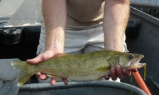
Features: Color varies, but walleye are generally dark olive-brown on top grading to almost white below. Walleye have two well-separated dorsal fins; the first fin has a large black spot at its rear base. The opaque eyes, giving the fish its common name, and canine teeth are other prominent features. Habitat: Walleye are found in the Columbia, Willamette and Snake rivers. In the Willamette River, the walleye fishery is generally limited to the section downstream from Willamette Falls at Oregon City, although a few have been documented as far upstream as Dexter Dam. Walleye prefer large, clean and cold or…
Features: Pumpkinseeds may be identified by the orange or red spot on the ear flap and the orange cheeks with wavy blue or turquoise stripes. Color is exceedingly brilliant and somewhat variable; olive to brassy-green above, the back finely dusted with gold or emerald. Habitat: Pumpkinseeds are found in the same habitats and often in association with bluegills. Adults often congregate beneath old deadheads and trees that have fallen into the water. Food habits are also similar to bluegill. They consume large numbers of snails by browsing on the stalks of aquatic vegetation. Techniques: Pumpkinseed are found in many of…

Find maps, boundary descriptions and the percent public land for the Wilson Unit.
Find maps, boundary information and the percent public land in the Rogue Unit.
Find maps, boundary descriptions and the percent public land for the Steens Mountain Unit.
Trout fishing opportunities abound in this zone, known for its high desert climate, sage-covered canyons, glacial peaks and mountain lakes. Anglers will find year-round trout fishing in the Deschutes, Metolius, Fall and Crooked rivers, while several central Oregon lakes and reservoirs are renowned for their trout and kokanee fishing – and their beauty. The Hood and lower Deschutes – both tributaries of the Columbia River – offer high desert fishing for Chinook salmon and summer steelhead.

Find maps, boundary descriptions and the percent public land for the Chesnimnus Unit.
Find maps, boundary descriptions and the percent public land for the Beatys Butte Unit.

Find maps, boundary descriptions and the percent public land for the Stott Mountain Unit.
Find maps, boundary descriptions and the percent public land for the Klamath Falls Unit.
Find maps, boundary descriptions and the percent public land for the Sprague unit.
Find maps, boundary descriptions and the percent public land for the Owyhee Unit.
Find maps, boundary descriptions and the percent public land for the Malheur River Unit.
Find maps, boundary descriptions and the percent public land for the Columbia Basin Unit.
Find maps, boundary descriptions and the percent public land for the Whitehorse Unit.