
Search myodfw.com
Showing 301 - 320 of 990 results
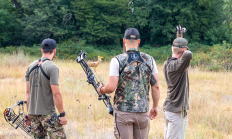
Our Mission The Oregon Department of Fish and Wildlife (ODFW) Hunter Recruitment Program is dedicated to strengthening and growing Oregon's hunting and shooting sports community. We provide hands-on skills training, promote a culture of safety, ethics, and conservation, and foster a positive public perception of hunting and shooting sports. Our goal is to build confidence, knowledge, and skills for both new and seasoned hunters, supporting a lasting connection to Oregon's rich outdoor traditions. Workshops are offered statewide throughout the year. View and register for an upcoming event: Classes and W or kshops.
SALEM, Ore. – The Oregon Department of Fish and Wildlife is accepting applications for the Chair position on the state Access & Habitat (A&H) Program Board. The deadline to apply is April 3, 2026. Application forms and additional information are available at: http://www.dfw.state.or.us/lands/AH/get_involved.asp The current Chair has completed the maximum…
Central Point, Ore. – Hunters and recreationists who plan to use the Jackson Cooperative Travel Management Area (TMA) should download the newest version of the georeferenced .pdf map. updated on Oct. 14. There have been major changes this year, so users should double check where they plan to access. These…
The FRWA was created by a licensing agreement signed in 1957 and modified in 1982 and 2008, between the US Army Corps of Engineers and the Oregon Game Commission. This agreement authorized the state to develop, conserve, and manage all wildlife resources on 5,261 acres of land and water within the Fern Ridge Project. ODFW also acquired the 309 acre Coyote Creek South and 224 acre Coyote Creek Northeast units in 2013 and 2015, respectively. The wildlife area now totals 5,794 acres.
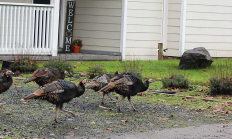
SE WILDLIFE VIEWING June 18, 2026 Harney County With warmer temperatures occurring throughout Harney County various orders of birds can be viewed including but not limited to Passeriformes, Galliformes, Accipitriformes, and Anseriformes. The county experienced a mild winter this season making for low snowpack accumulation even at higher elevations, access for observation opportunities should be good even early this summer. Although, those looking to explore rural areas of the county should keep recovery items in their vehicle. Early summer rains occurring periodically may cause muddy conditions on unpaved roads. With the late spring months comes wildlife baby season. Most wildlife…

The Columbia Basin Wildlife Areas are a composition of four Oregon Department of Fish and Wildlife (department) managed wildlife areas located along the Columbia River, in the Columbia Basin. The four wildlife areas (Power City, Irrigon, Coyote Springs and Willow Creek) are within the Columbia Plateau ecoregion. Management agreements for these areas were initially established between 1971 and 1977 between the department and Federal agencies which own the lands. The Columbia Basin Wildlife Areas, which total approximately 1,885 acres, provide an important landbase for the conservation and recreation of fish and wildlife within a highly privatized and altered landscape and…
SALEM, Ore. – ODFW invites the public to view artwork entered in the annual stamp art contest on Tuesday, Nov. 4 from 12:30-5:00 p.m. at ODFW Headquarters in Salem. The event is free and open to the public. Located at 4034 Fairview Industrial Dr SE, Salem, ODFW Headquarters will host…


When you sign up to be an ODFW volunteer, you're helping to protect Oregon's fish and wildlife, manage ODFW properties, and share your hunting and fishing experiences with others while creating a stronger appreciation for the outdoors. Already volunteering with ODFW
Year round opportunities
Various programs statewide
Lower Deschutes Wildlife Area was established in 1983, with the initial donation of land by the Oregon Wildlife Foundation (OWF) of 2,758 acres. In 1986 OWHF donated an additional 5,158 acres of land to the department. The Lower Deschutes Wildlife Area was initially established to provide permanent public angler access. However, especially with the 1986 acquisition, the wildlife area has grown to provide enhanced wildlife and fish habitat (i.e. through removal of livestock, riparian vegetation improvements, etc.) and more wildlife-oriented recreational activities such as hunting, boating, hiking and biking. In 2015, ODFW partnered with the Trust for Public Land to…
Following droughts in the 1930s that affected most of North America, major conservation efforts, by both private and governmental entities, were enacted to reverse trends of degrading and disappearing wetlands. During this time period there was a major creation and expansion of federal wildlife refuges and state wildlife areas. As the concept of waterfowl flyway management was endorsed and developed, wildlife areas were acquired and managed as part of a larger plan focused on migratory waterfowl needs. LMWA was one of several wetland-focused wildlife areas established in Oregon. Ladd Marsh Wildlife Area was established in 1949, with primary objectives of…
SW WILDLIFE VIEWING June 18, 2026 Coos and Curry counties Coquille Valley Wildlife Area (CVWA) Coquille Valley Wildlife Area (CVWA) in Coos County is open to public access. Permits for access are required and are available, free of charge, at the kiosk located in the parking lot along North Bank Road. You must access CVWA through this point. Please fill out the upper half ("A" half) of the permit and deposit it in the slot located on the post of the kiosk. Sign and carry the lower half ("B" half) with you while you enjoy CVWA. At the end of…
CENTRAL WILDLIFE VIEWING June 18, 2026 Crook County Spring ungulate migration will soon be upon us. You can find mule deer transitioning from low elevation winter feeding areas to the higher elevation sagebrush and agricultural areas. There are red-tailed, rough-legged and ferruginous hawks, northern harriers, American kestrels, prairie falcons and golden eagles throughout Crook County and they're usually associated more closely with open/agricultural areas. Bald eagles and ospreys, on the other hand, are more closely associated with water bodies. Look for northern goshawks throughout the Ochoco National Forest, and for ducks and geese in rivers and lakes. Prineville Reservoir Wildlife…
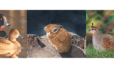
California quail are the most widely distributed upland game birds in Oregon. Most easily recognized by the comma-shaped, black, plume, or "topknot," which bends forward and is larger on the male. It has been a resident statewide since the early 1900s, except for most forests of the north Coast Range and west Cascades; it is generally absent along the coast north of Coos Bay. California quail is also absent from high-elevation areas of the east Cascade range. They are common residents in rural and even some suburban areas, particularly in eastern Oregon where many coveys gather at feeding stations during…
