
Search myodfw.com
Showing 341 - 360 of 990 results
The E.E. Wilson Wildlife Area came into existence in 1950 when the U.S. Government gave quitclaim title to the property to the Oregon Department of Fish and Wildlife. The wildlife area covers approximately 1,788 acres, is located on Highway 99W about 10 miles north of Corvallis and is situated on the Willamette Valley floor. SHOTGUN RANGE BACK OPEN AS OF LATE OCTOBER 2025: The renovation is complete and the shotgun range is back open. Improvements include: four times as many shooting lanes, fully paved ADA-compliant walkway with pullouts that will make it easier for disabled shooters, a new covered pole…
Coquille Valley Wildlife Area was initially established in 2013 with two equally important primary objectives; (1) To protect, enhance, and restore fish and wildlife habitats located on the WA, and (2) to provide a wide variety of wildlife-oriented recreational and educational opportunities to the public.
Game bird seasons in Oregon run from July 1 to June 30, which means you'll need to purchase new upland and waterfowl validations before you hunt again in the fall. If you have questions or need assistance, please call ODFW licensing staff at 503-947-6101. Buy license Check current Game Bird Regulations for details on licenses, tags, permits and validations. Purchase the federal duck stamp here to prepare for waterfowl season. Special permits-applications-forms *Use current published regulations by downloading a .pdf on your device. (AI-may contain inaccurate data).

A quiet, modest, unobtrusive little bird that must be sought to be seen in its shady retreats, this little-studied species can easily be overlooked. It is typically associated with oaks and mixed woodlands, where it hops along the foliage hunting for insects. In winter it forages with flocks of chickadees, kinglets, and nuthatches. This is Oregon's only resident vireo. Although it is sometimes referred to as non-migratory, some seasonal movement has been observed. Similar in appearance and behavior to the more common and widespread Ruby-crowned kinglet. Hear the song of the Hutton's vireo Photo by Greg Gilson

This majestically crested bird is often heard before being seen due to its conspicuous harsh rattling call. Kingfishers are most frequently associated with lake and pond shorelines and islands, as well as coastal dunes with ponds and widely scattered shrubs and trees. They hunt from a vantage point above water such as an overhead branch, telephone wires along shore lines or pilings of piers. This is a common permanent resident throughout most of the state except in the north Lake and east Deschutes counties where open water is generally absent Hear the call of the belted kingfisher Photo from ODFW

SALEM, Ore. – ODFW and the Oregon Hunters Association (OHA) will give away free wildlife forage seed to landowners at E.E. Wilson Wildlife Area near Corvallis on Saturday, May 9. The giveaway coincides with OHA's Youth Field Day (limited spots available). Seed giveaway More than 500 bags of free seed…
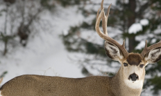
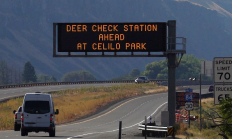
SALEM, Ore.— Hunters are the first line of defense against Chronic Wasting Disease (CWD). By getting their animals tested, hunters can help wildlife managers detect the disease early and slow its spread in the state's deer and elk herds. OHA and ODFW are again teaming up to encourage hunters who…
MARINE WILDLIFE VIEWING June 18, 2026 The Oregon coast is a great place to come and view a variety of wildlife. Enjoy the great diversity of life: from giant whales and barking sea lions to majestic bald eagles and diving pelicans, to showy Harlequin ducks and flocking shorebirds, to the tiny anemones and crabs inhabiting tidepools. There is always something new to discover. Visit our wildlife viewing map for locations to visit and view wildlife along the Oregon coast. Maximize your viewing of coastal creatures by bringing binoculars for close-up views. Beach Safety: Check conditions here Whales, orcas and porpoises…
With short pointed wings and long narrow tails, these small falcons are well built for fast pursuit and mid-air attacks. Sexes differ in color and size, with adult males about 25 percent smaller by weight than females. Males range from blackish gray to pale blue-gray on the back with a reddish wash along sides of the breast and a banded tail; females have brownish backs. In winter, it can be found throughout the state in open or semi-open habitats, but it is most regular near major estuaries, lakes, reservoirs, and occasionally in cities where food supplies are reliable. For nesting…

SALEM, Ore.—As 2025 deer and elk hunting seasons begin, ODFW is ramping up its Chronic Wasting Disease (CWD) surveillance statewide. Hunters are encouraged to take advantage of streamlined testing options and reminded that CWD check stations are mandatory to stop at when transporting harvested deer or elk. Sampling is quick…
The Northern harrier is a slender, medium-sized hawk characterized by a noticeably long tail, bold white rump patch, and owl-like face. Commonly encountered in large expanses of open country, its main hunting technique is through use of a distinctive buoyant, gliding flight low over the ground that relies heavily on visual as well as auditory cues to detect prey. The larger females have rich brown upperparts while adult males are mostly light to medium gray, sometimes appearing almost ghostly silvery-white. Males are noted for their high-spirited and acrobatic courtship displays, in particular a series of dives and barrel rolls in…

Round Butte Hatchery was constructed in 1972 to mitigate for the fishery losses caused by Pelton/Round Butte (PRB) Hydroelectric Complex. Round Butte and its satellite, Pelton Ladder, are used for adult collection, egg incubation and rearing of spring Chinook, summer steelhead, and sockeye salmon.
Pheasants, grouse, quail and turkey are all upland game birds that are chicken-like and ground-dwelling. Wild turkeys are the largest upland game bird in Oregon.

This release was updated April 25 to correct two errors (the first name of the OSP Lieutenant who testified on Sauvie Island parking issues and that the Don Lindly property was sold to Lincoln County not Lincoln City.) LINCOLN CITY, Ore.—The Commission adopted a limited entry parking program for summer…