Search myodfw.com
Showing 441 - 460 of 651 results
Features: Butter clams have oval and oblong shaped shells with heavy, thick valves and hinge. Their shells have fine concentric rings. When the shell is open a little, you can see the pale ruffled mantle reminiscent of a tuxedo. Like the gaper clam, they have their two siphons fused together into one "neck." Average adult size is 3-4 inches but can range up to 5 inches. Butter clams can live more than 20 years. Habitat: Butter clams can be found in a wide variety of substrates but prefer sand and gravel/cobble beaches. They live approximately 6-12 inches deep and can…

Find maps, boundary information and the percent public land in the Evans Creek Unit.
Find maps, boundary descriptions and the percent public land for the Mt. Emily Unit.
Find maps, boundary information and the percent public land in the Powers Unit.
Find maps, boundary information and the percent public land in the Tioga Unit.
Find maps, boundary descriptions and the percent public lands in the Ukiah Unit.
Find maps, boundary descriptions and percent public land for the Murderers Creek Unit.
Find maps, boundary descriptions and the percent public land for the Fort Rock Unit.

SALEM, Ore.— ODFW will host an open house on Tuesday, April 7 from 2-4 pm to discuss development of its 2027-29 Agency Request Budget. The meeting will be hosted in ODFW's headquarters classroom (4034 Fairview Industrial Drive, SE, Salem) and will be streamed online via YouTube. In Oregon, state agency budgets…
Find maps, boundary descriptions and the percent public land for the Lookout Mountain Unit.
Find the 2025-26 weekly statistics for waterfowl and upland game birds at Klamath Wildlife Area. More information about Klamath Wildlife Area
Find maps, boundary descriptions and the percent public land in the Biggs Unit.
Find maps, boundary information and the percent public land in the Chetco Unit.
SAUVIE ISLAND WILDIFE AREA, Ore.— To manage ongoing traffic and parking problems at Sauvie Island Wildlife Area's beaches, ODFW is introducing a new limited-entry parking pilot program. Starting July 4, vehicles will need a free Sauvie Island Beaches Pass in addition to the Wildlife Area Parking Permit ($10 daily) to…
Find maps, boundary information and the percent public land in the Paulina Unit.
Find maps, unit descriptions and the percent public lands in the Starkey Unit.
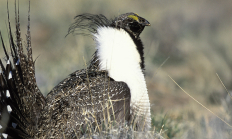
SALEM, Ore. – ODFW staff will host a webinar on July 17 at 2 p.m., to introduce the public to the updated ODFW sage-grouse management plan. The Oregon Greater Sage-grouse Conservation Assessment and Strategy was last updated in 2011. The public is invited to learn about proposed changes to the…