
Search myodfw.com
Showing 61 - 80 of 1673 results
The diversity of Oregon's habitats and terrain offers something for every hunter. From the densely forested Coast Range to the expansive sage steppe of the Great Basin, Oregon is a wonderland of hunting opportunities. Visit e-regulatons

The ring-necked duck, which would have been better named "ring-billed duck" and is called "blackjack" in the southeastern United States, frequents different habits than the scaups with which is is often confused. The black back, white crescent on the side just in front of the wing, and white-ringed bill separate the drake ring-neck from the scaups. The brownish neck ring of the male in alternate plumage is not prominent. The hen is a small dark brown duck with a buff face. Drakes in courtship give a head-throw accompanied by a wow note while hens utter a growling purr. Ring-necks are…

This Eurasian diving duck regularly occurs in the Aleutian Islands and with increasing regularity in North America, especially along the West Coast. It is now reported annually in Oregon, between mid-October and early May, with most during January and February. All were from the coastal lowlands or the Willamette Valley, except for one on a small pond in Josephine County. They are closely related to the scaups and often associated with them. Hear the call of the tufted duck Photo by Tom Benson, Flickr

Greater scaup are almost the size of redheads. In hand, they are easily distinguishable from lesser scaup by size and by the white wing stripe extending beyond the secondaries into the primaries. In the field the two species are sometimes difficult to separate. Drakes are black on both ends and white in the middle. Hens are dark brown with a white mask around the base of the bill. The common vocalizations are the discordant scaup and purring pbbbrr of the female. Greater scaups form large flocks, sometimes mingling with lesser scaups in fall and winter. They are an abundant migrant…

Known as "bluebill" to most hunters, this species is one of the most abundant and widespread of North American ducks. The lesser scaup is similar to the greater scaup in appearance and habits, but is smaller and lacks the white on the primaries. In the field, however, the black-and-white drakes and brown hens are very similar to greater scaups. The common vocalization is the purr call of the female; drakes are usually silent, but utter a low single-note whistle in courtship. In general, the lesser scaup is more apt to be found in interior or freshwater habitats while the greater…

This small, boldly-patterned duck can be found in Oregon throughout the year, either around rocky headlands on the coast or inland on mountain streams. No other breeding duck in Oregon feeds almost exclusively on benthic invertebrates, often swimming underwater and upstream against swift current in search of prey. Though males are striking in appearance, these and the drab brown females can be difficult to see when at rest on a mid-stream rock or dodging behind rocks as they evade observers. Broods have been observed or nests located on tributaries in the river basins of the west Cascades. They are found…

Although the least numerous scoter on the continent, it is the most common scoter along the Pacific coast south of Alaska and winters by the thousands off Oregon. Adult males' plumage, black except for white patches on the forehead and nape, yields attention to the bill, a swollen white, red-orange, yellow, and black wedge feathered squarely along its base. The highly visible standard advertises male's presence for up to a mile. Dark-billed adult females and subadults are dark brown above and paler brown below, with two indistinct light patches on the cheeks and sometimes on the nape. A flattened head…

The white secondaries of the white-winged scoter in all plumages form a conspicuous square wing patch during flight but are often hidden during rest. Other than the secondaries, males' plumage is entirely black except for a small white teardrop around each eye. Females and immatures are dark brown above and pale below with diffuse white patches in front of and behind the eyes. A black knob graces the males' swollen, white-ridged, orange bills, while females' and immatures' bills are dark; the feathering of all extends almost to the nostril. Abundant along the coast from fall through spring, white-winged scoters are…

Adult male scoters of all species are black, but black scoters are the blackest; their shiny black plumage bears no white. The swollen bright orange-yellow knob on the otherwise black bill is smaller than that of other scoters. Males are distinguished in flight by the flashing silver-gray of underwing flight feathers against black wing linings and the all-black body. Females' uniform soot upperparts and dark head cap are clearly delineated from paler cheeks; their bills are usually dark. Immatures resemble females, but most males acquire some black feathering the first fall. This scoter can be uncommon to locally common along…

This restless diver of cold oceans and bays is one of the prize waterfowl to see on a coastal winter day. Although the loud, musical call of males is seldom heard in Oregon, we can still be cheered on a chilly day by this energetic visitor from the north. The winter males' body is mostly white except for a black breast and central back; the wings are dark, scapulars long and gray, and the dark central tail feathers elongate. Winter females are darker above with a light head; scapulars and tail feathers are short and dark. Dark areas mark females'…

The bufflehead is North America's smallest diving duck, giving it the advantage of being able to nest in abandoned holes of northern flickers, a plentiful resource off limits to larger cavity-nesting ducks. It is a swift flyer and takes wing from water more easily and neatly than other diving ducks. Widely distributed throughout the state in winter, males attract attention with their striking white body, black back, and iridescent black head with a large notch of white; females and juveniles are dark charcoal-gray with a conspicuous white patch behind and below the eye. It is a local, uncommon breeder in…

The common goldeneye drake is a strikingly handsome black-and-white diver about the size of a greater scaup. Goldeneyes are strong, fast flyers nicknamed "Whistlers" for the sound of their primaries as they zoom past on a still day. Drakes have a black head with a white spot below and in front of the eye, white neck, breast and flanks and a black back and tail. Hens have a brown head, light neck, breast and belly, brown backs and flanks. They are fairly silent and usually alone or in small groups. They tend to remain apart from other ducks. It is…

Medium-sized diving ducks, Barrow's goldeneyes are the expected of the two goldeneye species in Oregon in the summer, but are typically less numerous in the winter. Drakes show graceful patterns of black and white, purple glossed head, white crescent-shaped patch between the eye and bill, steep forehead, and short bill. Females and juveniles have a chocolate-brown head, slate-gray back, wings and tail; adult females have a golden bill. They are the only waterfowl species known to defend winter territories different from breeding territories. It is uncommon from the Cascades eastward in both breeding season and winter, but it may concentrate…

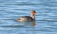
In quiet backwaters and wooded wetlands, these stunning ducks can occasionally be seen skulking near the shoreline as they search for fish. The male with a striking black head and extensible white crest, white breast, black back, and chestnut sides is truly a sight to behold. Females and immatures are quite plain by comparison: dull grayish-brown except for a reddish brown crest. Hooded mergansers are surprisingly secretive and local during the breeding season. They breed locally throughout the Willamette Valley west to the coast and south to Coos County. They are casual from April to early October in the Umpqua…

A white form on the distant water may be the sides and breast of an adult male, whose deep green head and dark back are less visable when far away. The pearl gray bodies and white breasts of females, subadults, and eclipse males are starkly delineated from their full-crested chestnut heads. Long, slender, saw-tooth bills are held horizontally during surface swimming and grip squirming prey after an underwater chase. From coastal bays to the high Cascades, in all corners of Oregon and far beyond, common mergansers ply the rivers and peer into still waters in their efficient pursuit of fish…

Swimming and diving with grace and energy, red-breasted mergansers arrive in fall but save their complex, contorting courtship display for early spring. A ragged-crested dark green head and reddish brown breast mark the male, along with a dark back and gray sides. Females share the ragged crest; their rufous heads and gray bodies may make separation from common merganser females difficult. Their bills, however, are noticeably slimmer. Red-breasted mergansers are common from fall through spring, mostly in coastal bays and estuaries but occasionally on the open ocean. Hear the call of the red-breasted merganser Photo by Jason Badger, ODFW
Small in size and displaying a showy, almost comical alternate plumage, the male ruddy duck is an unforgettable sight. Breeding males are unmistakable with their rich chestnut back, black crown, white cheek, sky-blue bill, and proportionately long stiff tail. Female plumage is drab in comparison, being dusky dark brown with a dark facial strip across the mostly white cheek, quite similar to the male's basic plumage. Known for their peculiar courtship display in which the male draws his head down and slaps his bill against his breast repeatedly in increasing tempo, creating a bubbling in the water and a hollow…

While not as abundant or conspicuous as the more familiar Canada and snow geese, the great white-fronted goose represents one of the first signs of fall. The greater white-fronted goose is gray-brown in body color and has orange feet. Adults have the namesake white forehead, pinkish-orange bill, and black speckled/barred breast and belly. Laugh-like calls from small skeins of these birds are heard high overhead in August through September in the north Willamette Valley and across the Cascades to south central Oregon and northeast California. Hear the call of the greater white-fronted goose Photo by Dave Budeau, ODFW

The emperor is a medium-sized stocky goose with a white head and metallic blue-gray body reminiscent of a blue-morph snow goose. Dark throat and undertail coverts as well as yellow feet distinguish it from the latter. Juveniles are brown with a gray-black head and neck that becomes white with black flecking in late fall. Vocalizations include in-flight kla-ha, kla-ha, kla-ha, and an alarm call a deep ringing u-lugh, u-lugh, u-lugh. The emperor is a rare but regular visitor in Oregon during migration and in winter, most commonly on the coast. Hear the call of the emperor goose Photo from USFWS

The skies near favored stopover locations are filled twice annually with the sights and sounds of these geese as they migrate between Arctic breeding grounds and wintering areas farther south. Snow geese share very similar all-white plumage and black wing tips with the less common Ross's goose. These are Oregon's only wild white geese. It is predominantly a spring and fall migrant, especially abundant in large wetland and agricultural complexes such as Malheur National Wildlife Refuge, Silvies River floodplain in Harney County, Lower Klamath National Wildlife Refuge and Klamath Wildlife Area. Wintering snow geese in Oregon are found primarily along…
