Search myodfw.com

The pelage of this mouse is grayish or brownish dorsally, the venter hairs are white with lead-colored bases, and the tail is light colored. In Oregon, it occurs within the area circumscribed by a line connecting Denio Nevada; Fort Rock, Lake County; Powell Butte, Crook County; Malheur National Wildlife headquarters, Harney County; and Burns Junction, Malheur County. On a daily basis, activity begins with an intense burst during the first light to hours after sunset, and declines to almost nil six hours after sunset, then, especially in summer, increases again before sunrise. The Dark Kangaroo Mouse constructs elaborate nests with…


Western Oregon observers enjoy these large, elegant plovers almost year-round, and as a consequence they are one of the most familiar larger shorebirds. Almost all migrants and winterers visiting Oregon inhabit mudflats and open wet dirt fields. A few can be found on sand beaches and even occasionally on rocks, but the great majority are found feeding and resting on open mud. In Oregon, it is a fairly common to common transient in western interior valleys. East of the Cascades, the Black-bellied plover is an uncommon transient in the Klamath Basin and at Malheur National Wildlife Refuge. In winter it…

A large, long-legged wader distinguished from similar species in a flight by flashing rufous underwings and dark brown primaries. Its feet extend beyond tail tip in flight. Flocks generally consist of fewer than 50 birds on the coast. Juveniles migrate south several weeks later than most adults. After mid-November, a few stragglers are seen until late December. The Marbled godwit is a regular spring and fall migrant on the Oregon coast. Spring migration commences in early April and extends through early June on the coast. Its average arrival at the Malheur National Wildlife Reserve is April 27. Hear the call…

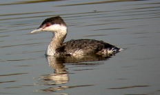
In alternate plumage this striking bird's lower neck, chest, and sides are bright chestnut. Three groups of yellow plumes adorn the sides of the head. Its head and throat are black. This grebe favors areas with much open water surrounded with emergent vegetation. The horned grebe is a rare breeder east of the Cascades. Malheur National Wildlife Reserve averages four to five pairs per summer. It is also rare along the coast in summer and is an uncommon spring and fall transient on lakes, reservoirs, and large rivers west of the Cascades and uncommon to common east of the Cascades…
The Bald eagle is one of eight species of sea-eagle worldwide, and the only sea-eagle found throughout North America. It is one of the most studied North American birds. Large size, wingspan of six-and-a-half to eight feet, and the contrast of white head and tail, and yellow eyes, beak, and leg, to dark brown body and wings make the adult Bald eagle one of our most distinctive raptors. Six age-related plumages have been recognized; adult plumage is acquired at four-and-a-half to five years of age. Sexes have similar plumages, but females are larger than males, and the sex of individuals…

The kit fox is the smallest canid that occurs in Oregon. It has the typical canid conformation: the body is slim, the legs are long and thin, and the ears are large and erect. The tail is about 40 percent of the total length and is tipped with black, but has no dark mane on the dorsal surface. The feet and legs are whitish interiorly, light rusty-brown posteriorly. The dorsum is grizzled brownish-gray medially blending to grizzled gray then to light buff laterally and finally to white on the chest and venter. The head and posterior surface of the ears…

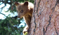
Black bears are the largest extant carnivores in Oregon. They are, however, smaller than grizzly bears, and they lack the grizzly's distinctive shoulder hump. A black bear is heavily built with stout legs and large feet. The eyes and ears are relatively small and the tail is extremely short. The claws are recurved but relatively short with those on the forefeet equal to or only slightly longer than those on the hind feet. The characteristic humped shoulders and dished face of the grizzly bear are absent. During spring-autumn seasons, black bears tend to be more active during daylight and crepuscular…
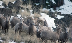
The bighorn sheep is a medium-sized, largely brownish bovid with a white rump patch, muzzle, venter, and rear portion of the legs. The tail is blackish brown on the exposed surface. The hooves are equipped with a rubberlike pad that facilitates negotiating rocky terrain. The ears are relatively small and somewhat pointed. Both sexes are equipped with horns; those of males are massive and spiral outward, whereas those of females are relatively thin, recurved, and mostly directed upward and posteriorly. Horn growth reflects nutritional status. Bighorn sheep are capable of moving with speed and agility through the precipitous terrain in…
Inconspicuous and master of stealth, the Least bittern inhabits densely vegetated deep-water marshes, making observations rare and difficult; its call is often the only way to detect this secretive species. The smallest of herons, its long neck and legs make it appear larger. The crown, back and tail of male birds is greenish black; purple-chestnut on female. Neck, flanks, and underparts are brown and white and the wings buff. It is a rare spring and summer resident in larger freshwater marshes of eastern Oregon and a very rare spring through fall visitor in the Rogue and Willamette valleys. At Upper…

One of Oregon's rarest breeders, this distinctive "shorebird" is known for its courtship display flight and loud curlew-like call. it often perches in pine trees or on fence posts adjacent to nesting areas. A small plover-like head and short, strait bill seem out of proportion to its body, which is reminiscent of a small curlew. The Upland sandpiper is a rare breeder in large montane meadows within forests of eastern Oregon. They are almost never observed away form the breeding grounds in Oregon. The Upland sandpiper is an Oregon Conservation Strategy Species in the Blue Mountains ecoregion. Hear the call…

Canvasbacks are large; adults in good condition are as heavy as mallards and second in size only to the white-winged scoter among common Oregon ducks. Drakes have a reddish head and neck; black breast, lower back and tail coverts; nearly white back, flank, and belly, and dark gray tail. The hen is grayish brown with a darker brown head, neck, breast and tailcoverts. It is an occasional summer resident in northeast Oregon, nesting locally only at Ladd Marsh in Union County. It is an uncommon spring and fall migrant in northeastern Oregon and regular in winter and spring on the…

Cattle egrets are the smallest of Oregon's three egret species, with short, stout neck and legs, and white body with orange-buff plumes on the head and nape in spring and early summer. They are named for their association with livestock, consuming insects on their backs or stirred up by their hooves. In Oregon, the Cattle egret is a casual transient in spring in the Klamath Basin and rarely in the Malheur National Wildlife Refuge. The least widespread of the state's egrets during the breeding season; a rare breeder in the Great Basin and a few pairs occasionally nesting at Malheur…

The nasal meow of the Franklin's gull can be heard as it soars above wetlands and meadows, and colonies of this species are reported to be the loudest of all the gulls. In breeding plumage, the black hood contrasts sharply with the white breast and bright red bill. This species depends much more on insects and other invertebrates than do other gulls, and is therefore considered economically beneficial and favored by farmers. The Franklin's gull occurs in the southeast portion of the state in spring and summer, especially Harney Basin. It is rare west of the Cascades. It nests locally…

Worldwide, frogs and toads are in trouble because of habitat loss, pollution, pesticides, climate change, diseases, the pet trade and competition from invasive species. Many of Oregon's 12 native species of frogs and toads are listed as Oregon Conservation Strategy Species of concern. Frogs and toads belong to the same animal group but are very different. Toads have dry, rough and bumpy skin covering a wide body while frogs are slender with smooth, moist skin. Frog eyes are higher on the head than toads and are rounder and bulging. And there's a reason we play "leap frog" - frogs take…

Known as "bluebill" to most hunters, this species is one of the most abundant and widespread of North American ducks. The lesser scaup is similar to the greater scaup in appearance and habits, but is smaller and lacks the white on the primaries. In the field, however, the black-and-white drakes and brown hens are very similar to greater scaups. The common vocalization is the purr call of the female; drakes are usually silent, but utter a low single-note whistle in courtship. In general, the lesser scaup is more apt to be found in interior or freshwater habitats while the greater…

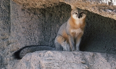
The gray fox is among the smaller canids in Oregon. The basic color of the gray fox is grizzled gray, but the stiff middorsal hairs have long black tips that extend onto the tail as a black mane. Guard hairs are banded white, gray, and black. The throat, venter, and inside of the legs are white; a cinnamon-rufous border to the white throat extends on the flanks and underside of the tail A blackish patch on the side of the face extends onto the lower jaw and a grayish black "exclamation point" extends upward from the interior margin of each…
