
Search myodfw.com
Showing 361 - 380 of 903 results
The E.E. Wilson Wildlife Area came into existence in 1950 when the U.S. Government gave quitclaim title to the property to the Oregon Department of Fish and Wildlife. The wildlife area covers approximately 1,788 acres, is located on Highway 99W about 10 miles north of Corvallis and is situated on the Willamette Valley floor. SHOTGUN RANGE BACK OPEN AS OF LATE OCTOBER 2025: The renovation is complete and the shotgun range is back open. Improvements include: four times as many shooting lanes, fully paved ADA-compliant walkway with pullouts that will make it easier for disabled shooters, a new covered pole…
SALEM, Ore. – Oregon may soon have a new wildlife area in Union County called the Qapqápa Wildlife Area (pronounced cop-COP-a). The property would be owned by the Oregon Department of Fish and Wildlife (ODFW) and co-managed with the Confederated Tribes of the Umatilla Indian Reservation (CTUIR), continuing a decades-long…
Coquille Valley Wildlife Area was initially established in 2013 with two equally important primary objectives; (1) To protect, enhance, and restore fish and wildlife habitats located on the WA, and (2) to provide a wide variety of wildlife-oriented recreational and educational opportunities to the public.
Game bird seasons in Oregon run from July 1 to June 30, which means you'll need to purchase new upland and waterfowl validations before you hunt again in the fall. If you have questions or need assistance, please call ODFW licensing staff at 503-947-6101. Buy license Check current Game Bird Regulations for details on licenses, tags, permits and validations. Purchase the federal duck stamp here to prepare for waterfowl season. Special permits-applications-forms *Use current published regulations by downloading a .pdf on your device. (AI-may contain inaccurate data).

The Klamath Fish Hatchery was originally constructed in 1929. Many improvements have been made since original construction. The hatchery produces legal and trophy sized rainbow trout, fingerling rainbow trout, brown trout, and cutthroat trout for release throughout the Klamath Basin, Deschutes Basin, Umpqua Basin and the southeast part of the state. The hatchery assist with remote egg takes for wild rainbow and brown trout at Crane Prairie and Wickiup Reservoirs.

White River Wildlife Area was established in 1953. Located along the east slope of the Cascade Mountains in the north central part of Oregon, the wildlife area encompasses 29,480 acres. An additional 1,280 acres of land owned by the Bureau of Land Management (BLM) is managed by the ODFW bringing the total acres managed by the department to 30,760. The primary purpose of White River Wildlife Area is to provide winter range habitat for black-tailed deer and Rocky Mountain elk and to minimize big game damage to adjacent private agricultural lands.

Sauvie Island Wildlife Area protects vital waterfowl habitat and provides a public hunting area while supporting a rich diversity of wildlife, including hundreds of bird, mammal, reptile, and plant species.
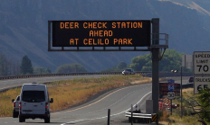
SALEM, Ore.—As 2025 deer and elk hunting seasons begin, ODFW is ramping up its Chronic Wasting Disease (CWD) surveillance statewide. Hunters are encouraged to take advantage of streamlined testing options and reminded that CWD check stations are mandatory to stop at when transporting harvested deer or elk. Sampling is quick…
Find maps, boundary information and the percent public land in the Upper Deschutes Unit.
Spring, fall and winter are the seasons when most big game hunters will be in the woods or on the grasslands. Visit e-regulations

Jewell Meadows Wildlife Area is located in the Oregon Coast Range Mountains, in the northwestern part of the state. The wildlife area was established in 1969, with an initial purchase of 183 acres. It now encompasses 1,114 acres. The wildlife area’s purpose is to protect and enhance habitat to benefit native wildlife species, to reduce wildlife damage to adjacent properties, and to provide the public with an opportunity to observe wildlife in a natural setting.
Find maps, boundary descriptions and the percent public land for the Imnaha Unit.
Find maps, boundary descriptions and the percent public land for the Owyhee Unit.
