Search myodfw.com
Showing 421 - 440 of 909 results
Find maps, boundary descriptions and percent public land for the Fossil Unit.
Find maps, boundary descriptions and the percent public land for the Silver Lake Unit.
Find maps, boundary descriptions and the percent public land for the Willamette Unit.
Find maps, boundary descriptions and the percent public land for the Santiam Unit.

Find maps, boundary descriptions and the percent public land for the Sled Springs Unit.
Find maps, boundary descriptions and the percent public land for the Indigo Unit.
Find maps, boundary information and the percent public land in the Paulina Unit.
Find maps, unit descriptions and the percent public lands in the Starkey Unit.
Find maps, boundary descriptions and percent public land for the Murderers Creek Unit.
Find maps, boundary information and the percent public land in the Chetco Unit.
Find maps, boundary descriptions and the percent public land for the Melrose Unit.
Oregon has one species of kingfisher, the raucous Belted kingfisher and 12 woodpecker species. Six woodpeckers are Oregon Conservation Strategy Species of management concern and in need of conservation. Famous for their hammering and hole drilling, woodpeckers might decide your home looks like a good place to set up shop. Learn how to discourage this on our Living with Wildlife, Birds page.

Find maps, boundary descriptions and the percent public land for the Fort Rock Unit.


WILLAMETTE WILDLIFE VIEWING June 25, 2026 Corvallis area EE Wilson Wildlife Area There are lots of deer, shorebirds and waterfowl to see on the wildlife area – look for goose, mallard, hooded merganser and wood duck broods. Wildlife viewing remains good for waterfowl and shorebirds. Note: Dogs are required to be on a leash inside the wildlife area boundary. Rifles and pistols are prohibited year-round. Find directions to EE Wilson Wildlife Area. A parking permit is required to park at EE Wilson Wildlife Area. Find out how to buy a parking permit. Eugene area Fern Ridge Wildlife Area Observant visitors…
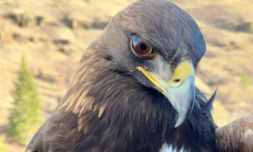
NE WILDLIFE VIEWING June 25, 2026 Baker County Bighorn sheep can be seen in the Burnt River Canyon west of Durkee or along the Snake River Road south of Richland. The best viewing is in the early morning and late in the evening. Take the Snake River Road between Richland and Huntington to see bald and golden eagles along the Snake River. There are deer throughout the valley. Early in the morning and late in the afternoon are good times to view wildlife. A drive through the foothills of the Baker valley and through the Keating valley can turn up…
The European starling is considered an invasive species in Oregon. It was introduced from Europe. They most closely resemble blackbirds, with which they often flock in fall and winter. While both have iridescent plumage, starlings can be told from blackbirds by their two-toned wing pattern - dark upperwing, pale underwing - and during the breeding season by the bright yellow bill. Starlings adapt readily and quickly to human habitation and are highly efficient and successful breeders. However, the abundance of the bird, the rapidity with which it has spread across North America, and its propensity to cause damage to crops…