
Search myodfw.com
Showing 141 - 160 of 333 results
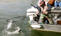
Each year, ODFW stocks millions of trout in dozens of reservoirs, lakes and ponds throughout the state. You can use the search and filter functions to search the stocking schedule for specific locations and dates. The schedule is subject to change without notice; see individual waterbody listings in the Recreation Report for updates.
Find maps, boundary descriptions and hunts available in the new Devils Garden Hunt Area. Download printable PDF map
Find maps, boundary descriptions and hunts available in the new Fox Hunt Area FX-02. Download printable PDF map
Find maps, boundary descriptions and hunts available in the new Trout Creek Hunt Area. Download printable PDF map

Find maps, boundary descriptions and hunts available in the new Elkhorn Hunt Area. Download printable PDF map
Find maps, boundary descriptions and hunts available in the new Painted Hills Hunt Area. Download printable PDF map
Find maps, boundary descriptions and hunts available in the new Sage Hen Hunt Area. Download printable PDF map
Find maps, boundary descriptions and hunts available in the new Aldrich Hunt Area. Download printable PDF map
Find maps, boundary descriptions and hunts available in the new Deschutes Hunt Area. Download printable PDF map
Find maps, boundary descriptions and hunts available in the new Elkhorn Hunt Area. Download printable PDF map
Find maps, boundary descriptions and hunts available in the Juntura Hunt Area. Download printable PDF map
Find maps, boundary descriptions and hunts available in the new Sage Hen Hunt Area. Download printable PDF map
NEWPORT, Ore. – Ocean sport salmon fishing closes at 12:01 a.m., Tuesday, Aug. 19 in the Columbia River Subarea (Leadbetter Pt., WA to Cape Falcon, OR) and possession of salmon on board a vessel is prohibited. Fishing is allowed on Monday and is closed Tuesday. Projected harvest of marked (fin-clipped)…
Find maps, boundary descriptions and the percent public land for the Willamette Unit.
Establishment of the Bridge Creek Wildlife Area initially started in 1961 when a parcel of land was purchased from the Frank Hilbert estate. After the initial purchase, several private holdings were acquired to consolidate the land under department ownership. The last parcel was purchased from the Colvin Cattle Company in 1975. The primary purpose of the wildlife area is to maintain and protect a key historic winter range for Rocky Mountain elk ( Cervus elaphus nelsoni).
Coquille Valley Wildlife Area was initially established in 2013 with two equally important primary objectives; (1) To protect, enhance, and restore fish and wildlife habitats located on the WA, and (2) to provide a wide variety of wildlife-oriented recreational and educational opportunities to the public.
The FRWA was created by a licensing agreement signed in 1957 and modified in 1982 and 2008, between the US Army Corps of Engineers and the Oregon Game Commission. This agreement authorized the state to develop, conserve, and manage all wildlife resources on 5,261 acres of land and water within the Fern Ridge Project. ODFW also acquired the 309 acre Coyote Creek South and 224 acre Coyote Creek Northeast units in 2013 and 2015, respectively. The wildlife area now totals 5,794 acres.
Find maps, boundary descriptions and hunts available in the new Crooked River Hunt Area. Download printable PDF map