

Search myodfw.com
Showing 181 - 200 of 510 results
Press Release
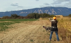
Events in Coquille, Central Point, Monmouth, Eugene, Irrigon, John Day, Klamath Falls, La Grande, Madras, Portland, Tygh Valley SALEM, Ore.—Youth hunters (age 17 and under) who will have completed hunter education by the time of the event can sign up now for ODFW's free pheasant hunts happening around the state…
August 5, 2025
Landing page
Find maps, boundary descriptions and the percent public land for the Wilson Unit.
September 05, 2017
Landing page
Find maps, boundary descriptions and percent public land for the Fossil Unit.
September 05, 2017
Landing page
Find maps, boundary descriptions and the percent public land for the Willamette Unit.
September 05, 2017
Zones or Areas
The southwest zone includes Umpqua River, Coos Bay, Coquille River, Port Orford, Rogue River and Chetco River - all of which offer shellfishing.
Landing page
Find maps, boundary information and the percent public land for the White River Unit.
September 05, 2017
Press Release
SALEM, Ore. – The Oregon Fish and Wildlife Commission adopted a management plan for the Minam Wildlife Area, approved a land acquisition for Denman Wildlife Area and heard an update on Oregon's Native Seed Strategy. The plan was the result of extensive engagement with the tribes, community partners, and the…
March 20, 2026
Landing page
The FRWA was created by a licensing agreement signed in 1957 and modified in 1982 and 2008, between the US Army Corps of Engineers and the Oregon Game Commission. This agreement authorized the state to develop, conserve, and manage all wildlife resources on 5,261 acres of land and water within the Fern Ridge Project. ODFW also acquired the 309 acre Coyote Creek South and 224 acre Coyote Creek Northeast units in 2013 and 2015, respectively. The wildlife area now totals 5,794 acres.
February 26, 2018
Landing page
Find maps, boundary descriptions and the percent public land for the Scappoose Unit.
September 05, 2017
Zones or Areas
Trout fishing opportunities abound in this zone, known for its high desert climate, sage-covered canyons, glacial peaks and mountain lakes. Anglers will find year-round trout fishing in the Deschutes, Metolius, Fall and Crooked rivers, while several central Oregon lakes and reservoirs are renowned for their trout and kokanee fishing – and their beauty. The Hood and lower Deschutes – both tributaries of the Columbia River – offer high desert fishing for Chinook salmon and summer steelhead.
Article
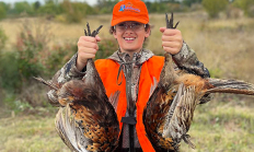
Youth game bird hunt opportunities give young hunters a chance to hunt in a controlled setting with a focus on safety and success.
August 5, 2025
Landing page
Find maps, boundary descriptions and hunts available in the new Fox Hunt Area. Download printable PDF map
November 14, 2025
Landing page
Find maps, boundary descriptions and the percent public land for the Beulah Unit.
September 05, 2017
Article
ODFW wants to make sure our uniformed service members are given the opportunity to participate in the outdoor recreation Oregon has to offer.
April 15, 2026
Landing page
Find the weekly statistics for waterfowl and upland game birds at Ladd Marsh Wildlife Area. More information about Ladd Marsh Wildlife Area
September 22, 2017
Zones or Areas
The granite peaks of Oregon’s Blue and Wallowa Mountains form the backdrop for many of this zone’s glacier-carved lakes and crystalline streams. Bull trout thrive in this zone’s cold, clear rivers, which also sustain whitefish and rainbow trout, and welcome returning runs of hatchery-reared steelhead. Chinook salmon travel over 300 miles up the Columbia to spawn in rivers such as the Imnaha and Wallowa. Warmwater fisheries are few, but the John Day River offers world-class fishing for smallmouth bass.
Zones or Areas
Abundant rainfall feeds the massive Willamette River watershed, tamed by a system of reservoirs that are stocked annually with hundreds of thousands of rainbow trout. Some of these reservoirs also grow trophy-size largemouth and smallmouth bass, as well as bluegill, brown bullhead and crappies. Smaller lakes and ponds nearer the valley floor provide springtime trout fishing close to home. Salmon and steelhead navigate the Willamette River and its tributaries, many of which are also home to rainbow and cutthroat trout.
Zones or Areas
Wide open spaces, wild windy places, and extreme temperatures characterize Oregon’s largest, most remote fishing zone. Redband trout are native to its rivers and streams, including the Williamson, Malheur and Chewaucan. Brown and hatchery rainbow trout can grow to trophy-size in many of its lakes and reservoirs, many of which also feature crappie, yellow perch and bass.
Landing page
Find maps, boundary descriptions and hunts available in the new Devils Garden Hunt Area. Download printable PDF map
November 13, 2025