

Search myodfw.com
Showing 401 - 420 of 777 results
Landing page
Find maps, boundary descriptions and the percent public land for the Keno Unit.
September 05, 2017
Landing page
Find maps, boundary descriptions and the percent public land for the Pine Creek Unit.
September 05, 2017
Zones or Areas
Abundant rainfall feeds the massive Willamette River watershed, tamed by a system of reservoirs that are stocked annually with hundreds of thousands of rainbow trout. Some of these reservoirs also grow trophy-size largemouth and smallmouth bass, as well as bluegill, brown bullhead and crappies. Smaller lakes and ponds nearer the valley floor provide springtime trout fishing close to home. Salmon and steelhead navigate the Willamette River and its tributaries, many of which are also home to rainbow and cutthroat trout.
Zones or Areas
Wide open spaces, wild windy places, and extreme temperatures characterize Oregon’s largest, most remote fishing zone. Redband trout are native to its rivers and streams, including the Williamson, Malheur and Chewaucan. Brown and hatchery rainbow trout can grow to trophy-size in many of its lakes and reservoirs, many of which also feature crappie, yellow perch and bass.
Workshop and Events
ORDER Replacement Hunter Safety Card
Date
Available
Location
Online
Landing page
Find maps, boundary descriptions and the percent public land for the Catherine Creek Unit.
September 05, 2017
Species and Subspecies
Features: Largemouth bass are greenish on the back and sides with a white belly and usually a dark horizontal stripe along the side. They are distinguished from their close cousin, the smallmouth, by a large mouth with the upper jaw extending behind the eye. Largemouth bass in Oregon can exceed 25 inches in length and a weight of 12 pounds. Habitats: Their preferred habitats are shallow ponds and lakes, or the backwater sloughs of rivers where aquatic plants or submerged logs and brush provide abundant cover. Largemouth bass begin life feeding on zooplankton (tiny crustaceans), but soon switch to insects…

Landing page
Find maps, boundary descriptions and the percent public land for the Interstate Unit.
September 05, 2017
Landing page
Find maps, boundary descriptions and the percent public land for the Keating Unit.
September 05, 2017
Landing page
Find maps, boundary information and the percent public land in the Upper Deschutes Unit.
September 05, 2017
Landing page
Find maps, boundary descriptions and the percent public land for the Siuslaw Unit.
September 05, 2017
Landing page
Find maps, boundary descriptions and the percent public land for the Walla Walla Unit.
September 05, 2017
Landing page
Find maps as well as boundary and the percent public land for the Metolius Unit.
September 05, 2017
Landing page
Find maps, boundary descriptions and the percent public land for the Wagontire Unit.
September 05, 2017
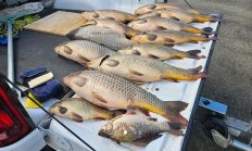
Press Release
ROSEBURG, Ore. – Illegally introduced common carp were found in Cooper Creek Reservoir near Sutherlin. ODFW verified an angler's report of carp in Cooper Creek last week by electrofishing, removing 14 adult carp, most of which were pregnant females ranging in age from approximately two to eight years old. This…
April 21, 2026
Landing page
Find maps, boundary descriptions and the percent public land for the McKenzie Unit.
September 05, 2017
Landing page
Find maps, boundary information and the percent public land in the Ochoco unit.
September 05, 2017
Landing page
Find maps, boundary descriptions and the percent public land for the Wenaha Unit.
September 05, 2017
Landing page
Find maps, boundary descriptions and the percent public lands for the Desolation Unit.
September 05, 2017
Landing page
Find maps as well as boundary and percent public land for the Grizzly Unit.
September 05, 2017