
Search myodfw.com
Showing 1 - 20 of 201 results
Find maps, boundary descriptions and percent public land for the Murderers Creek Unit.
Find maps, boundary descriptions and the percent public land for the Pine Creek Unit.
Find maps, boundary information and the percent public land in the Evans Creek Unit.
Find maps, boundary descriptions and the percent public land for the Catherine Creek Unit.
Gnat Creek Hatchery was constructed in 1960 as part of the Columbia River Fisheries Development Program (Mitchell Act)—a program to enhance declining fish runs in the Columbia River Basin. The facility is used for egg incubation and rearing of spring Chinook and winter steelhead. Most of the production is released off-station. The hatchery is an easy drive toward Oregon’s coast on Highway 30 and a visitor-friendly place for the entire family. With lots to do, located on beautiful Gnat Creek and tucked away amid the rainforest, this is a worthwhile stop on the way to the coast.
The present facility was constructed in 1925, across the North Umpqua River from an earlier trout hatchery built in 1920. The hatchery was closed in 1975 due to low stream flows and high water temperatures, and was reopening in 1979 after extensive reconstruction. In 2012 a state of the art fish passage ladder was completed. It included a fish viewing window for Rock Creek basin fish inventory and a fish trap facility. The hatchery produces fall and spring Chinook, coho, summer and winter steelhead, and rainbow trout. The facility is used for adult collection, spawning, incubation, and rearing of Chinook…
Big Creek Hatchery began operation in 1941. It was refurbished in 1957 under the Mitchell Act as part of the Columbia River Fisheries Development Program – a program to enhance declining fish runs in the Columbia River Basin. The facility is used for adult collection, egg incubation and rearing of winter steelhead, fall Chinook, and coho.
SALEM, Ore. – Effective June 1 through Sep. 30, minimum and maximum size limits as well as the daily and possession bag limits for rainbow trout and bass are suspended for Thief Valley Reservoir, Pilcher Creek Reservoir, and Wolf Creek Reservoir which are all located within the Southeast Zone in…
Construction of this facility began in 1924 and production started in 1925 by the state of Oregon. Various renovations have taken place with the most recent being the addition of 4 new fish rearing raceways and improvements to the pollution abatement system which was completed in 2016. Other renovations made throughout the hatchery have utilized the Restoration and Enhancement Program.. The purpose of this facility is to enhance spring Chinook, winter steelhead, summer steelhead, and coho populations for various coastal streams. The facility is used for adult collection, egg incubation and rearing of spring Chinook, fall Chinook, winter steelhead, summer…
Establishment of the Bridge Creek Wildlife Area initially started in 1961 when a parcel of land was purchased from the Frank Hilbert estate. After the initial purchase, several private holdings were acquired to consolidate the land under department ownership. The last parcel was purchased from the Colvin Cattle Company in 1975. The primary purpose of the wildlife area is to maintain and protect a key historic winter range for Rocky Mountain elk ( Cervus elaphus nelsoni).
Find maps, boundary descriptions and hunts available in the new Trout Creek Hunt Area. Download printable PDF map
The Columbia Basin Wildlife Areas are a composition of four Oregon Department of Fish and Wildlife (department) managed wildlife areas located along the Columbia River, in the Columbia Basin. The four wildlife areas (Power City, Irrigon, Coyote Springs and Willow Creek) are within the Columbia Plateau ecoregion. Management agreements for these areas were initially established between 1971 and 1977 between the department and Federal agencies which own the lands. The Columbia Basin Wildlife Areas, which total approximately 1,885 acres, provide an important landbase for the conservation and recreation of fish and wildlife within a highly privatized and altered landscape and…
Find maps, boundary descriptions and hunts available in the new Trout Creek Hunt Area. Download printable PDF map
The Bureau of Land Management maintains a series of pastures along Oregon Highway 38 that are a year-round residence for a herd of 60-100 Roosevelt elk. Elk are visible almost every day of the year!
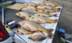
ROSEBURG, Ore. – Illegally introduced common carp were found in Cooper Creek Reservoir near Sutherlin. ODFW verified an angler's report of carp in Cooper Creek last week by electrofishing, removing 14 adult carp, most of which were pregnant females ranging in age from approximately two to eight years old. This…
LA GRANDE, Ore. – Lookingglass Creek, a tributary to the Grande Ronde River at Palmer Junction, will open to fishing for hatchery spring Chinook on Friday, May 15. The open area is from the mouth upstream to the confluence of Jarboe Creek. Depending on which happens first, the fishing season will remain open through June 14 or until…
LA GRANDE, Ore. – Lookingglass Creek, a tributary to the Grande Ronde River at Palmer Junction, will open for spring Chinook fishing Wednesday, June 18 through Sunday, June 29. The open area is from the mouth upstream to the confluence of Jarboe Creek. After early season projections made it appear…
July 2, 2025 THE DALLES, Ore.—With another poor forecast for Columbia Basin summer steelhead runs this year, protective regulations are again in effect on some tributaries (Deschutes, John Day, Eagle Creek). The daily adult salmon and steelhead bag limit may not include more than one hatchery steelhead in the following…
PENDLETON, Ore. – A $1 million federal investment will jump-start critical engineering and design work on fish passage and alternative solutions at McKay Creek Reservoir Dam, laying the technical groundwork to eventually reconnect more than 100 miles of historic salmon and steelhead habitat. Sens. Jeff Merkley and Ron Wyden helped…
CLACKAMAS, Ore. – Angling will be closed on the lowest reach of Eagle Creek in the Clackamas basin from Sept. 27 through Oct. 31 to give coho salmon a safe resting area amid ongoing low water flows. The closure is from SE Dowty Road downstream to the Clackamas River confluence…