
Search myodfw.com
Showing 201 - 220 of 396 results
NEWPORT, Ore. – ODFW is accepting nominations for a seat on the Pacific Fishery Management Council (Council). The three-year term for this Oregon at-large seat begins Aug. 11, 2026. Anyone interested in being considered, or wishing to nominate someone, must contact Jessica Watson at 541-351-1196 or jessica.l.watson@odfw.oregon.gov . Completed application…
Find maps, boundary descriptions and hunts available in the new North Blues Hunt Area. Download printable PDF map
A dozen great rivers pour out of the Coast Range Mountains into tidal bays that welcome runs of salmon and steelhead. Bays are the year-round home to marine perch, rock fish, crabs and clams, while other species come and go with the seasons and tides. A handful of ponds dot the forested slopes, and there are dozens of dune lakes— many stocked with rainbow trout, and some harboring largemouth bass, perch, crappie and brown bullhead.

Find maps, boundary descriptions and hunts available in the new Steens Hunt Area. Download printable PDF map
Find maps, boundary descriptions and hunts available in the new Fox Hunt Area. Download printable PDF map
Find maps, boundary descriptions and hunts available in the new Juntura Hunt Area. Download printable PDF map
Find maps, boundary descriptions and hunts available in the new Klamath Basin Hunt Area. Download printable PDF map
Find maps, boundary descriptions and hunts available in the new DeGarmo Hunt Area. Download printable PDF map

Find maps, boundary descriptions and hunts available in the new Devils Garden Hunt Area. Download printable PDF map
Find maps, boundary descriptions and hunts available in the new Fox Hunt Area FX-02. Download printable PDF map
Find maps, boundary descriptions and hunts available in the new Trout Creek Hunt Area. Download printable PDF map
Each year, ODFW stocks millions of trout in dozens of reservoirs, lakes and ponds throughout the state. You can use the search and filter functions to search the stocking schedule for specific locations and dates. The schedule is subject to change without notice; see individual waterbody listings in the Recreation Report for updates.
Each fathom line, conservation area, and marine reserve is defined by a connecting series of waypoints (latitude and longitude). The waypoints are used for regulatory enforcement, while maps are provided for visual reference.
There is year-round salmon, steelhead, trout and smallmouth bass in the Southwest Zone. Rainbow trout are stocked in the upper Rogue River and in lakes nestled among fir forests and wind-swept dunes. Big reservoirs provide fishing for trout and for thriving populations of largemouth bass, catfish, perch and crappie. Coastal bays serve as gateways to rich offshore reef fisheries, and miles of public beach allow anglers to fish for surfperch against a backdrop of rugged capes.
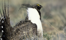
SALEM, Ore. – ODFW staff will host a webinar on July 17 at 2 p.m., to introduce the public to the updated ODFW sage-grouse management plan. The Oregon Greater Sage-grouse Conservation Assessment and Strategy was last updated in 2011. The public is invited to learn about proposed changes to the…
NEWPORT, Ore. – The Oregon Department of Fish and Wildlife is hosting a Feb. 2 public meeting beginning at 6 p.m. to get input on the number and timing of fixed and back-up dates for the central Oregon coast spring all-depth Pacific halibut season. The meeting is in the conference…
Find maps, boundary descriptions and hunts available in the new Elkhorn Hunt Area. Download printable PDF map