
Search myodfw.com
Showing 381 - 400 of 815 results


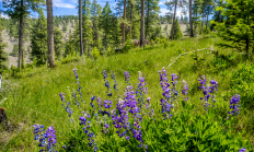
Oregon's diverse habitats and terrain offers something for every hunter. From the densely forested Coast Range to the expansive sage steppe of the Great Basin, hunting opportunities are practically unlimited. Visit e-regulations

SE WILDLIFE VIEWING June 18, 2026 Harney County With warmer temperatures occurring throughout Harney County various orders of birds can be viewed including but not limited to Passeriformes, Galliformes, Accipitriformes, and Anseriformes. The county experienced a mild winter this season making for low snowpack accumulation even at higher elevations, access for observation opportunities should be good even early this summer. Although, those looking to explore rural areas of the county should keep recovery items in their vehicle. Early summer rains occurring periodically may cause muddy conditions on unpaved roads. With the late spring months comes wildlife baby season. Most wildlife…
SALEM, Ore. – Oregon may soon have a new wildlife area in Union County called the Qapqápa Wildlife Area (pronounced cop-COP-a). The property would be owned by the Oregon Department of Fish and Wildlife (ODFW) and co-managed with the Confederated Tribes of the Umatilla Indian Reservation (CTUIR), continuing a decades-long…
Protecting and enhancing Oregon’s fish and wildlife, and the habitats they use, for the use and enjoyment of present and future generations is at the heart of what we do.


CENTRAL WILDLIFE VIEWING June 18, 2026 Crook County Spring ungulate migration will soon be upon us. You can find mule deer transitioning from low elevation winter feeding areas to the higher elevation sagebrush and agricultural areas. There are red-tailed, rough-legged and ferruginous hawks, northern harriers, American kestrels, prairie falcons and golden eagles throughout Crook County and they're usually associated more closely with open/agricultural areas. Bald eagles and ospreys, on the other hand, are more closely associated with water bodies. Look for northern goshawks throughout the Ochoco National Forest, and for ducks and geese in rivers and lakes. Prineville Reservoir Wildlife…

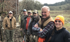
When you sign up to be an ODFW volunteer, you're helping to protect Oregon's fish and wildlife, manage ODFW properties, and share your hunting and fishing experiences with others while creating a stronger appreciation for the outdoors. Already volunteering with ODFW
Year round opportunities
Various programs statewide
Coquille Valley Wildlife Area was initially established in 2013 with two equally important primary objectives; (1) To protect, enhance, and restore fish and wildlife habitats located on the WA, and (2) to provide a wide variety of wildlife-oriented recreational and educational opportunities to the public.

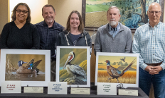
SALEM, Ore. – The winning artwork has been selected for the 2026 Oregon Waterfowl, Upland Game Bird, and Habitat Conservation Stamp Art Contests. In the Waterfowl Stamp category, first place went to Richard Clifton of Milford, Del., for his artwork featuring a blue-winged teal. For the Upland Game Bird category…
Prineville Reservoir Wildlife Area came under the shared management of the Oregon Department of Fish and Wildlife & United States Bureau of Reclamation in 1962. It is managed for the protection and enhancement of wildlife habitat, big game winter range, improving riparian wetlands, and to promote wildlife stewardship. Goals of the PRWA include creating recreational opportunities for viewing and enjoying wildlife, including mule deer, bald eagles, and a variety of waterfowl. Boating, hiking, and camping are a few popular activities permitted in the wildlife management area. Hunting and fishing opportunities are also available within Prineville Reservoir Wildlife Area, as regulated…
The E.E. Wilson Wildlife Area came into existence in 1950 when the U.S. Government gave quitclaim title to the property to the Oregon Department of Fish and Wildlife. The wildlife area covers approximately 1,788 acres, is located on Highway 99W about 10 miles north of Corvallis and is situated on the Willamette Valley floor. SHOTGUN RANGE BACK OPEN AS OF LATE OCTOBER 2025: The renovation is complete and the shotgun range is back open. Improvements include: four times as many shooting lanes, fully paved ADA-compliant walkway with pullouts that will make it easier for disabled shooters, a new covered pole…