Search myodfw.com
Showing 841 - 860 of 897 results

Find maps, boundary descriptions and the percent public land for the Scappoose Unit.
Find maps, boundary descriptions and the percent public land for the Stott Mountain Unit.


CLACKAMAS, Ore. – Sturgeon retention in Bonneville Pool and The Dalles Pool will open for one day on Monday, Feb. 16. These retention fisheries had not opened on the traditional date of Jan. 1 as in previous years. Due to warmer-than-normal winter water temperatures, increased angling effort, and high catch…
REDMOND, Ore. — Anglers have a lot to look forward to this fall: many coastal basins will see expanded opportunity for wild fall Chinook harvest compared to last year, and wild coho fisheries will continue across much of the coast, offering a strong season ahead. For fall Chinook, wild Chinook…
Find maps, boundary descriptions and the percent public land for the Beulah Unit.
Find maps, boundary descriptions and the percent public land for the Minam Unit.
Find maps, boundary descriptions and the percent public land for the Silvies Unit.
Each fathom line, conservation area, and marine reserve is defined by a connecting series of waypoints (latitude and longitude). The waypoints are used for regulatory enforcement, while maps are provided for visual reference.
SALEM, Ore.— Hunters are the first line of defense against Chronic Wasting Disease (CWD). By getting their animals tested, hunters can help wildlife managers detect the disease early and slow its spread in the state's deer and elk herds. OHA and ODFW are again teaming up to encourage hunters who…
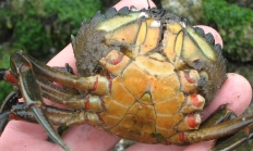
While recreationally harvesting green crab has been allowed for decades, the Oregon Fish and Wildlife Commission recently increased the daily bag limit to 35 crab. This gives recreational shellfishers an opportunity to help native shellfish by taking more of these invaders home. European green crab are an invasive species in Oregon. While recreational harvest is allowed (35 per day), harvesters must correctly identify these crabs (see below) as they often are mistaken for native species. Green crab: Compete with native crabs for food. Larger green crab may eat smaller native shellfish. May disturb eelgrass beds important to native fishes and…